(Continued from Chapter 12, Section 1):
SECTION 2
 Fig. 12.99. Planimetric map of the Station 7 layout, showing the locations of Pans 23, 24; the locations of various rock samples; and the position of the LRV with respect to the location of the large boulder (black oval) that was sampled (Modified from [[1]]).
“You want me to help you with the dusting, Geno?”
“No, I’ll get it. Only one guy can do it. …You take a pan [as] before [coverage], and we’ll start picking up some of those samples, and I’ll take a pan afterward. …Well, let’s see here. …See what kind of variety we can get here.”
“There is another one of our blue-gray breccias, I think, over there: re-crystallized breccias with some of that crushed anorthosite in it. …I think right in here. I’m going to take the pan at about…”
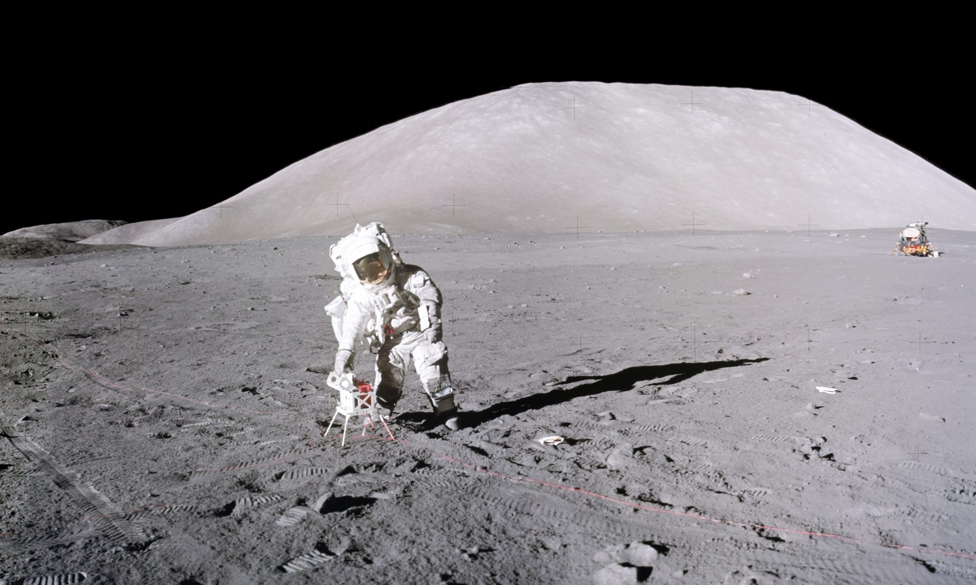
“And, Jack, what’s your frame count?” interrupted Parker.
“131.” I must have misread the indicator, as I had taken a number of photographs during our traverse to Station 7. The count was probably 141. “Bob, I’m going to take the pan at 11 feet [focus], so you can see the fragments that we’re going to pick up here. Then we can take another one for location work.” This panorama consists of AS17-141-21646-64. 21651-55 are the before images of the many small rocks I would sample.
 Fig. 12.100. The series of photos from my Pan 23 sequence is shown as quarters in these next four figures. This view looking south includes the large, squarish boulder at top right labeled “c” in Fig. 12.71↑ of §1. The distance between me and boulder “c” is ~108 m as measured on the LROC Quickmap. This image may give the reader a better idea on how hard it is to judge distances on the Moon. For a higher resolution view in a separate window, click here. (Composite of NASA photos AS17-141-21660, -661, -662, -663).
 Fig. 12.101. The view looking towards the east. The oval outlines a shallow depression with my footprints. The text spans the area where I picked up the indicated samples described below. For a higher resolution, unlabeled view in a separate window, click here. (Composite of NASA photos AS17-141- 21656, -657, -658, -659).
 Fig. 12.102. The view looking north. Cernan is working at the LRV, which was not fully framed. To the left of the Rover some of its tracks can be seen. The oval continues the area of shallow depression marked in Fig. 12.101. My footprints continue from the Rover. Three specific samples discussed below are indicated. A higher resolution, unlabeled view in a separate window, is available here. (Composite of NASA photos AS17-141-21651, -652, -654, -655).
 Fig. 12.103. The down-sun view looking west, which shows the relation between the Sta. 7 boulder (not fully framed at middle right) and boulder “c” at left. The bright area between my shadow and the boulder above is a result of the intense back-scattering from the regolith. The boulders on the horizon in the distance at middle left are the fragments of the Sta. 6 boulder (See Fig. 12.136↓ for a larger view). By computing the size of boulder “c”, deceptive distances and perspectives on the Moon can be demonstrated. The reseau marks are 10.3º apart in the original frame (AS17-141-21647) and if we use the distance of 108 m, the horizontal dimension is ~7.1 m whereas the vertical dimension is ~5.9 m (as a check on the photogrammetric trigonometry, the actual horizontal dimension can be measured directly with the LROC QuickMap tool; at 0.5 m/px resolution, 5 measurements gave 7 ± 0.89 m) . The boulder in this view is therefore comparable to looking at the LM Challenger at one end of an American football field from the other end! For a higher resolution view in a separate window, click here. (Composite of NASA photos AS17-141-21647, -648, -649, -646).
 Fig. 12.104. The altitude vs. distance of a line between me and boulder “c”. The mean slope is ~6.5°. The noteworthy point is the 25 m diameter crater between ~32 m and ~57 m. This crater cannot be seen in Fig. 12.103, probably because of the gradual upturn in the terrain (of about 1 in 20 m) masking its rim between 10 m and 30 m in front of me. (graph produced by the LROC QuickMap).
 Fig. 12.105. The LROC QuickMap view showing the locations of the Sta. 6, 7 and a,b,c boulders at 0.67 m/px. The large 25 m crater described in Fig. 12.104 is clearly seen between the Sta. 7 and “c” boulders. The original view can be accessed at the QuickMap website, https://bit.ly/3mnk9OR.
“Should have it (TV), Bob,” Cernan reported.
“We’ve got a TV. And, I repeat, we’d like to get some dusting of the [TCU] mirror and the lens of the TV; [that is, the] TCU and the TV.
“Let me get you out of the Sun. …I wouldn’t do this for anybody but you, you know that.”
“Okay. Looks good, Gene,” Parker replied. “Thank you…”
“You know what? I’m getting tired of dusting. …My primary tools: the dust brush and the hammer…and my head. …Okay. You ready to start picking [up rocks]?”
“Picking,” I replied, tersely, as I leaned into the slope, with the scoop handle in my midsection, and bagged a sample. Once bagged, I did my usual three-rotation twirl to close the bag.
“You notice the temperature difference with that high Sun angle?” commented Cernan.
“Yup.”
“Roger,” Parker said, not resisting the impulse to chide me on my visor. “You’re probably letting in a lot of infrared through without having that gold visor down, too. That’s sort of an infrared shield.” The problem, if one existed, would be UV radiation as Parker should have known; however, I rarely let sunlight in, directly, having grown up in the sunny Southwest.
“Yeah, but mine’s been down all the time, Bob,” countered Cernan, “…except in the shade.”
“Okay, 540 (77510-26) is the first bag of selected samples (location in Fig. 12.101↑),” I reported. “Okay. I’m going to leave your [SCB] open, but don’t let me [forget to close it].”

 Fig. 12.106. (Upper): The bottom side of rock sample 77515, a micropoikilitic impact melt breccia with a thick patina and numerous zap pits and small vesicles. Its location is marked in Fig. 12.102↑. (NASA photo S73-23496). (Lower): Anaglyph constructed from two convergent stereo views. For a higher resolution view of the anaglyph, click here. (Derivative of NASA photos S73-23496, ‑496B).
[I tried to get as many surface rock fragments as possible in this sample bag. Most of the samples 77510-14 turned out to be a single friable, fine-grained breccia that had broken into five pieces by the time it arrived in Houston for study. Three of the other fragments, 77515, 77518 and 77519, are impact and impact-melt-breccias with Mg-suite affinities. 77517, however, appears to be exotic relative to other North Massif rock samples. As the orthopyroxene in 77517 is aluminous, and it is associated with aluminous spinel, it may have originally formed at high pressure at the base of the solidifying lunar magma ocean where a proto-mineral Mg-garnet would be stable, actually forming a solid solution with aluminous orthopyroxene. 77517 probably should be added to 72415, 76535, and possibly 79215 as probably derived from the deep mantle by the overturn effects of the Procellarum large basin-forming event. (see Chapter 13).
77516 is a medium-grained olivine-ilmenite basalt similar to subfloor gabbro or basalt with the olivine appearing as small phenocrysts in a matrix of intergrown laths of ilmenite, plagioclase and pyroxene.
Post-mission examination of 77511, the regolith incorporated with the rock samples in 77510-14, provided an intermediate-high Is/FeO maturity index of 80. This higher maturity relative to the soils at Station 6 may relate to Station 7’s position on a significantly less steep slope on the regolith apron at the base of the North Massif. Down-slope replenishment of fresh debris would be at a slower rate here than at Station 6.]
“Let me get [this rock]. …Here, put that one (rock) in there [too].”
“Wait a minute,” I cautioned, “let’s get a bag on it. We’re getting too many rocks [without bags], and we don’t know where they came from…”
“I don’t think it will fit [in a bag]. Will it?”
“Well, we’ll wrap it a little bit.” This way the sample will at least have a bag number.
“Yeah, wait a minute, it will fit. …Wait a minute.” Cernan works the bag around the sample.
“Okay. Bag 541 (77017) is partially around another big rock in Gene’s collection bag…” As I reported this, I retrieved my scoop by stepping on its angled head and grabbing the raised handle.

 Fig. 12.107. (Upper): The unusual appearance of sample 77017 with chunks of feldspathic material suspended in a frothy black glass coating. (see Fig. 12.102↑for location) (NASA photo S73-17768). (Lower): A 3D anaglyph of the same sample. The depth perception of the rock structure is excellent (few in the Press saw this sample originally, so it lacks the sobriquet of “marshmallow chocolate mousse”, or perhaps even “Rocky Road”, an American ice cream!). A higher resolution version can be downloaded in a separate window by clicking here. (Derviative from NASA photos S73-17845, S73-17845B).
[Post-mission examination of 77017 disclosed that it is an unusual monomict breccia with the clasts comprised entirely of olivine-pyroxene-plagioclase gabbro in a matrix of vesicular glass rather than finely crystallized impact melt. Augite and pigeonite pyroxene crystals in the clasts contain inclusions of olivine and plagioclase, indicating a recrystallization event, that is, a metamorphic event at some point after this Mg-suite rock originally crystallized at depth in the crust.
Analysis of the matrix glass indicated that it is derived from a mix of the local regolith and the olivine gabbro, suggesting that 77017 is regolith breccia that happened to include a Mg-suite fragment of olivine gabbro. A 40-39Ar age date on a dikelet of this glass that cuts a clast gave 1.5 billion years and probably dates the impact into regolith that formed the breccia. ]
“Did you get pictures of this thing here?” Cernan referred to the nearby, large boulder.
“Yeah; well, not the big rock yet. Not in focus anyway.”
“I got to do that.” He stepped away to avoid his shadow and began to document the large boulder.
“I was just collecting [rocks] in this area.”
“Why don’t you keep grabbing a few, and I’m going to [get the pictures].” Cernan’s flight-line stereo images are AS17-146-22298-315.
 Fig. 12.108. Generally, as Cernan moved around the boulder at Station 7, he took two images, one up and one down to cover the total height. This is the first of nine 2-image views, some are vertical; others are offset. Part of the norite clast can be seen at the right edge. A large scale view in a separate window can be downloaded here. (Combination of NASA photos AS17-146-22298, -299).
 Fig. 12.109. The second pair provided a seamless image for the entire height of the boulder. This view of the east face of the boulder shows, from right to left, the large knobby, light norite clast, blue-gray melt-breccia, and tan-gray vesicular melt-breccia. A large scale view in a separate window can be downloaded here. (Combination of NASA photos AS17-146-22300, -301).
 Fig. 12.110. In this third offset pair, the light-colored norite clast takes up most of the central area of the boulder. A small part of boulder “c” can be seen at the middle left edge of the Sta. 7 boulder. A large scale view in a separate window can be downloaded here. (Combination of NASA photos AS17-146-22302, -303).
 Fig. 12.111. The fourth pair is also offset and the norite clast is now centered in the image. A large scale view in a separate window can be downloaded here. (Combination of NASA photos AS17-146-22304, -305).
 Fig. 12.112. The fifth pair is skewed because the camera was pointing off normal to the verticle plane through the boulder in opposite directions between the two photos. A large scale view in a separate window can be downloaded here. (Combination of NASA photos AS17-146-22306, -307).
 Fig. 12.113. Pair 06 provides an excellent view of the norite clast and two dikelets that cut across it marked by the red arrows. The dashed contour outlines the clast itself. Closer views of the dikelets are also shown in Fig. 12.117↓ below. The large scale, unmarked view can be downloaded here. (Combination of NASA photos AS17-146-22308, -309).
 Fig. 12.114. Pair 07, further to the right, shows a large part of the blue-gray breccia on the right side of the photo. Note the rather large micrometeorite impact pit with the white halo at the lower right near ground level just above the shadow. A large scale view in a separate window can be downloaded here. (Combination of NASA photos AS17-146-22310, -311).
 Fig. 12.115 As Cernan moves around the boulder in Pair 08, the blue gray part of the boulder dominates. The zap pit is visible near ground level at right; and boulder “c” behind the Sta. 7 boulder is emerging to the right. A large scale view in a separate window can be downloaded here. (Combination of NASA photos AS17-146-22312, -313).
 Fig. 12.116. Cernan’s 9th pair completes his flightline stereo sequence. The LM-sized boulder “c” has completely emerged into view ~107 m away. A large scale view in a separate window can be downloaded here. (Combination of NASA photos AS17-146-22310, -311).
[As discussed below, AS17-146-22298-308 (see Fig. 12.109↑ through Fig. 12.114↑ above) primarily show the blue-gray melt-breccia in the Station 7 boulder and the knobby, irregular surface of a large, ~2 m tall and ~1.5 m wide , roughly planer, norite clast that dominates the east side of the boulder. The norite clast that remains on the boulder is flat, but may be the side of what is a much larger, clast in the original outcrop. Apparent concentrations of plagioclase in the thicker portions of the clast suggest that the original norite mass was layered.
The tan-gray, vesicular melt-breccia is visible in the upper left of these images (globular-shaped area) with the contact between the two melt-breccias trending from upper right to lower left, beginning at the center apex.[2] AS17-146-22309, -311, and -313 show a black, extremely fine-grained dikelet cutting through the norite clast. (The thicker dikelet, together with a thinner one are marked in Fig. 12.117↓ which can be compared with Fig. 12.114↑)]
“That’s what I’m doing.” I was getting a little impatient to have a look at the large boulder.
“It’s one of the blue-gray rocks, Bob.” Cernan observed as he took a flight-line set of stereo photographs of the northeast face of the boulder. “And it’s got a light-colored fragment that runs the full height of it, about a meter and a half thick (wide). And then it’s got the blue-gray rock on the other side. As a matter of fact, …let me look at it closely. …It’s a [large] fragment in it all right.” At the completion of his flight-line stereo sequence, Cernan took a series of close-up images of the norite clast (AS17-146-22316-28), using his sampling tongs to refine the focus of his Hasselblad. 22320-28 of this sequence includes images of the black dikelets that cut through the clast, whereas, 22326-28 are specifically the before sampling images of the largest dikelet (Fig. 12.116↑). The afters are 22329-30 (Fig. 12.117, below).

 Fig. 12.117. (Upper) Black, glassy dikelets that originate from the blue-gray melt-breccia and cut the large norite clast. The upper photo shows a thin dikelet cutting across the lower part of the clast marked by the red arrows. (Lower) The wider dikelet above it marked between the red arrows. See Fig. 12.114↑ for positions of both together. The dashed circle marks the area from where samples 77075 and 77077 will be taken. ((Upper) NASA Photos AS17-146-22323 and (Lower) AS17-146-22327).
 Fig. 12.118. This photo shows the dikelet area in the red circle after the samples were removed. In all these photos, Cernan is using the tongs to maintain an accurate distance for the focus setting. (NASA photo AS17-146-22329).

 Fig. 12.119. (Upper): Sample 77075, an impact melt dikelet in cataclastic norite taken from the end of the upper vein as indicated in Figs. 12.117↑, 12.118↑. The dike material is the dark part and the white is the noritic material. (Informally, sometimes referred to as the ‘Baked Potato’) (NASA photo S73-23995). (Lower): An anaglyph from a convergent stereo pair. A larger-scale view in a separate window is available here. (Derived from NASA photos S73-23995, -23995B).
“Okay. Copy that, Gene,” responds Parker. “And remember to document around the corner if you’re trying to get some photo-documentation of the boulder.”
“Bob, I wouldn’t be absolutely positive,” Cernan continued, “but it sure looks like I see a dikelet in here, that’s in the inclusion. And I’m going to get a close-up stereo of it. I’d call it a dikelet, if you pinned me down.
“Okay. Copy that.”
“Pin him down,” I joked, as I finished bagging another selection of small rocks. In this sampling, I first get a fragment or two in the scoop and then grasp the scoop’s handle with my right hand about a foot from the scoop itself to ease the process of pouring the fragments into a sample bag held in my left hand.
“I wish I could break a sample right off,” Cernan said. “Here’s another one. It is a dikelet! There’s three or four of them!” Cernan’s exposure to geology in the field over the last fifteen months was paying off. “Ohhhh, me, oh, my. …The material in the dike looks… yeah, it is, it is, it’s (dikelet material) not covering it (the inclusion). It’s between the lighter-colored rock, and it’s the blue-gray rock.” Cernan is less than clear about what all these “its” refer to.
“542 (77530-45; rock suite sample location in Fig. 12.101↑) is another bag of goodies” I reported. “Gene, let me get rid of this [sample bag],” and I walked over to where Cernan worked at scraping some dikelet fragments off the boulder and put the “bag of goodies” in his SCB.
 Fig. 12.120. (Upper left): Rock sample 77535, a vesicular pyroxene-ilmenite basalt (NASA photo S73-25008). (Upper right): Sample 77536, also an ilmenite basalt (NASA photo S73-23828). (Lower left): The 3D anaglyph of 77535 composited from convergent stereo photos. The larger scale version of the anaglyph is available here. (Derived from NASA photos S73-25013, ‑2513B). (Lower right): The 3D anaglyph of 77536 composited from convergent stereo photos. The larger scale version of the anaglyph is available here. Both anaglyphs bring out the vesicles, zap pits, and the patina. (Derived from NASA photos S73-23838, -23828B).
 Fig. 12.121. Two more examples from the “bag of goodies”. (Left): Sample 77538, a trace-element-rich fragmental breccia with a light-colored matrix. It is covered with a patina and zap pits on all sides (NASA photo S73-19066). (Right): Sample 77539, an impact melt rock with a rare anorthosite clast. Vesicles and zap pits are also evident. There were no convergent stereo pairs for either sample. (NASA photo S73-19062).
[The mixed sample, 77530-45, contained some regolith, 77530-34, and six coherent rock fragments. 77535 is a medium-grained, vesicular pyroxene-ilmenite basalt while 77536 is a medium-grained, vesicular and porphyritic olivine basalt. 77538 is a fine-grained, plagioclase dominated impact breccia. The other two fragments, 77539 and 77545, are polymict, vesicular impact and impact-melt-breccias with Mg-suite clasts. As we became closer to the valley floor, more familiar examples of basalt had appeared in the regolith. (Figs. 12.120, 12.121 above show examples).
The regolith sample, 77531, consists of 54% agglutinate and 8.3% basalt and orange and black ash fragments. The Is/FeO maturity index is 79. A study of regolith samples from both the North and South Massif slopes and the light mantle[3] indicates that, compositionally, more than 25% of the of North Massif regolith from Stations 6 and 7 can be attributed to material introduced from the basalts and pyroclastic ashes on the valley floor. On the other hand, less than 10% of the regolith at the base of the South Massif and on the light mantle avalanche deposit reflects the addition of subfloor basalt and pyroclastic ash, probably due to the avalanche removing old regolith from the South Massif slope, on the one hand, and having rock fragments sink in its fluidized, flowing mass on the other hand.
It is likely that, temporarily at least, ash originally blanketed the slopes of the North and South Massifs 3.5 billion years ago, just as it did the valley floor. On one hand, in situ basaltic regolith development on the valley floor would gradually incorporate ash to create the dark mantle regolith unit, whereas meteoritic bombardment on the steep slopes of the massifs would have moved ash gradually downhill, concentrating it at the base. There, continuous downward movement of breccia-dominated regolith from slopes would have overridden ash concentrations at the foot of each massif. ]
“Oh, wait a minute,” Cernan hesitated. “I got…I got [fooled]. …Well, maybe it isn’t a dikelet. Maybe it’s just a screen [of glass] covering…a [glass] flow covering.”
“No, you got [it right]. …They’re dikes,” I assured him now that I could begin to look closely at what he had been trying to describe. …They’re little veinlets of [black, glass-like material in the large light-gray clast].” By using the word “veinlets”, I hoped to convey a little more clearly what we were looking at. Dikelet is the better term as they apparently formed by the injection of molten rock rather than being minerals deposited from a hot, water-rich solution (hydrothermal mineral vein).
“Let me get this whole thing in a bag,” Cernan said. “I got a rock, Bob. It’s fractured, primarily [from] around the dike. It’s in several pieces, but we’re going to put it all in one bag.”
“[Bag] 543 (77215),” I reported.
“Oh, man, they’re going to have to [re]assemble that.” As I held the bag open for him, Cernan continued, “Here. …Let me get it piece by piece…”
 Fig. 12.122. The fragments, 77215, of the cataclastic norite, the oldest lithology of the Station 7 boulder. The undevitrified noritic glass found in 77215 provides an understanding of the thermal history of this boulder. The photos generally showed a light gray, or lighter albedo color of the norite in situ; however, in the laboratory the fresh pieces were pure white apart from some patches of patina and zap pits as illustrated here. (NASA photo S73-17779).
[Post-mission analysis of 77215 shows that the large, light-gray to white clast in blue-gray breccia is crushed and sheared norite with about 75% made up of fragments of orthopyroxene (41%) and plagioclase (54%). Augite (clinopyroxene) has exsolved internally from the orthopyroxene, suggesting that the original pyroxene consisted of Ca-rich orthopyroxene that was subjected to a slow annealing event after its original crystallization. Although crushed, only a small amount of the plagioclase has been converted to maskelynite by shock.
Rock fragments within the primary norite clast include norite (8%), anorthosite (10%), noritic glass (6%), and troctolite breccia (<1%). Plagioclase crystals in norite fragments enclose small crystals of K-feldspar as well as granitic glass. Dikelets similar to 77075, discussed below, cut thought the clast samples and have the same composition as the bulk norite.
Chapter 13 includes a summary of post-mission data on Apollo 17 Mg-suite samples. ]
“Okay. We need to get a [sample of the dike],” I said. “Put one of those [pieces of the] dikes in another bag. …Bob, it looks like some fraction of the blue-gray material has obviously intruded [the large clast].”
[The dikelet connects directly with the blue-gray melt-breccia on its north contact with the norite clast, suggesting that melt from the blue-gray melt-breccia was injected into the norite clast; however, this would be inconsistent with its composition being that of the clast and not the breccia, as mentioned above. This inconsistency suggests that the melt that formed the dikelets was generated by heating or shock and subsequently migrated from the clast into open fractures. As will be discussed below, the younger tan-gray melt-breccia in contact with the blue-gray melt breccia may have been hot enough to partially remelt the latter as well as the norite clast.]
“Not too full. That’s all right.”
“Now, can you get that dike there?”
“[A] piece of it?”
“This thing,” I directed, pointing to a slight projection on the dikelet. “Can you get that?”
“I can get it right here.”
“No, I think…No, get the piece with the [projection]. …You get more of it, right there.” For some reason, Cernan would not rely on my judgment about where to break off a sample. Instead, he began to make large swings with the hammer, rather than just using his wrist to take what the rock would give him.
“Yeah. …It’s this soft, white inclusion again. It breaks pretty easy. …Oh, it’s got to be a dike. Look at that.”
“It is. …It is.” I reassured him, again. “Okay, [bag] 544 (77075-77, Fig. 12.119↑).
“Oh, yeah, it is, because I just broke into it.” Now, Cernan finally visualized the three-dimensional nature of the dikelet.
“Yeah.” I agreed.
“Get all of that [sample]?” I asked, monitoring what Cernan was doing to get a sample of the dikelet.
“Yeah. I’ll get it all.”
“Well, you don’t have [the dikelet contact],” I cautioned. As usual, I really wanted to do the chipping, myself.
“And we’d like to have you guys moving again in 5 minutes to get to Station 8 on time.” Somebody had lost perspective about a “bird in the hand”; however, we did need to see if we could obtain some insights into the Sculptured Hills mystery.
“Yes, sir,” I replied, perfunctorily, and then went on. “…although the blue-gray [breccia] up on the hill (Station 6) looked like a fragment breccia, if this [blue-gray unit here] is still related [to it], then [vesicles indicate] it’s been [through] some partial [re]melting at some time.”
“There’s a preserved contact between the dike and the white material (inclusion or clast),” Cernan observed.
“That’s what I wanted,” I told him. “That’s what I wanted.”
“Why don’t we get this big piece of dike now?” he suggested.
“See if you can get…” I stopped as Cernan prepared to hit the dikelet a second time. “Whoa! Don’t hit it again, …There, you’ve still got some contact [left] there.” He did not understand the importance of being able to collect any evidence of reaction across this contact.
“Now, there’s some good contact,” Cernan said as he worked the hammer more gently. “Man, that’ll do it” and he put the hammer in his calf pocket.
“Dike and intruded rock [are] in [Bag] 544 (77075),” I repeated. “Now, these dikes are a dark bluish-gray. And it looks like they’re very finely crystalline – maybe with some…very fine phenocrysts.”
[The dikelet, 77075, largely consists of a very fine-grained crystalline (sub-ophitic) matrix of plagioclase and pyroxene with minor olivine and ilmenite. The dikelet’s original melt probably cooled quickly due to its fine-grained texture and less than 3 cm thickness. The matrix of the dikelet includes mineral clasts of Ca-plagioclase, olivine, and orthopyroxene, rather than being phenocrysts as I had first surmised. (Phenocrysts would have crystallized from the melt whereas zenocrysts would have been mineral clasts broken from pre-existing rock.) The relatively high iridium content of the dike indicates that some meteoritic material was mixed with the noritic melt, raising the possibility that the dikelet’s impact-generated melt was externally derived from a different, but similar noritic parent.
The Rb-Sr isochron age for 77075 is 4.09 ± 0.08 billion years. At 4.00 ± 0.04 billion years, and recognizing possible contamination by older clasts, the dikelet’s 40-39Ar age lies within the error limits for those determined for the blue-gray impact melt-breccia in the boulder at Station 6, interpreted as related to the Crisium basin impact[4]. Blue-gray melt-breccia at Station 6 has been reheated by relatively younger light-gray melt-breccia that has roughly the same radiometric age within the error limits. The reported 40-39Ar age for the main norite clast at Station 7 is the same as the dikelet. It will take more precise dating in the future to determine if there is a significant radiometric age difference between these two, blue-gray melt-breccias.
Unlike most Mg-suite rocks, the Rare Earth Element profile of the noritic material next to the dikelet is lower relative to chondrites than the main norite clast (77215). This profile in the dikelet’s wall rock also does not show significant europium depletion in contrast to depletion apparent in the main norite clast. On the other hand, the dikelet itself shows europium depletion similar to the norite clast whose overall composition it matches. These contrasting profiles might be explained if Rare Earth Elements, and particularly europium, migrated from the original melt of the dikelet into the norite clast with europium being assimilated by plagioclase in the norite. At this time, final conclusion on the origin of the dikelet melt is difficult to make with the data at hand, some of which appear conflicting.]
“Get [the samples in] my bag,” Cernan said. “I’ll take some close-up’s.
I put the dikelet samples away in his SCB and then moved along the boulder face to try to understand the rest of what it could tell us. “We ought to get, …well, …we ought to get a piece of the normal blue-gray that the dikes are coming from, …You got your hammer handy still?”
“Yep,” he answered and handed me the hammer. “I want to get this finish documenting (photographing in stereo) this thing (boulder).” He used the tongs set the focus. The after sampling images are AS17-146-22329-30 (Fig. 12.118↑).
“Go ahead.”
“Ah-hah!,” I exclaimed as I moved around the boulder toward the south. “Hey, over here on this [south] side, it looks like the vesicular anorthositic gabbro.” Using the field terminology I had started using at Station 6, I referred here to a close similarity to the light-gray impact melt-breccia that lies against and is relatively younger than the blue-gray breccia in Station 6’s Block 2.
“I got to get some regular pictures around this [north] side. Okay. Here’s the [dikelet].” Cernan said to himself and then looked over to what I was doing to his left. “[If] that one won’t come off; this one will,” Cernan said, watching me trying to get a sample of the blue-gray breccia with about 10 light taps on the edge of a fracture. “Got it?” he asked as a piece came off.
“Yeah.”
“[Bag] 561 (77115),” reported Cernan.
 Fig. 12.123. (Upper left): The freshly broken surface of the impact melt blue-gray breccia 77115 which I took from the Station 7 boulder with 10 light hammer taps. It shows a couple of largish, white lithic clasts with smaller dark, mineral clasts in between. (NASA photo S73-24129) (Upper right): Sample 77115 rotated to show more of the exterior patina with zap pits. (NASA photo S73-24115) (Lower left): Anaglyph made from convergent stereo photos of 77115. A higher resolution version can be downloaded from here. (Derived from NASA photos S73-24129, ‑129B). (Lower right): Anaglyph of the rotated view made from convergent stereo photos. of 77115. A higher resolution version can be downloaded from here. (Derived from NASA photos S73-24115, -115B).
“That’s a sample of the [blue] gray – looks like re-crystallized breccia – that the dikes are continuous with, …and a, …Bob, it’s my turn to say ‘and a’.” Parker was trying to interrupt to hurry us along. “And the vesicular rock…” I moved about a meter farther south, tapped the slight shelf below a fracture five times and a nice piece of the light-gray vesicular impact-melt-breccia came loose in my left hand.
“Let me finish the stereo around the corner here,” Cernan said, suggesting that I get out of his way.
 Fig. 12.124. Composites of Cernan’s last documentation of the Station 7 boulder are shown in these next three illustrations. This view is looking down sun. Part of the large norite clast can be seen around the right edge. The very white part marks the site of sampling the upper dikelet. The contact between the light gray vesicular melt-breccia and blue gray melt-breccia curves down the middle of the boulder (see Fig. 12.127↓). A large scale view in a separate window is available here. (Combination of NASA photos AS17-146-22335, -336).
 Fig. 12.125. In this view, I am stepping up to take a sample from the boulder which is at the level of my helmet. I had already removed sample 77115 with 10 taps of the hammer (white area left of center, see Fig. 12.127↓). The larger scale view is available here. (Combination of NASA photos AS17-146-22333, -334).
 Fig. 12.126. Cernan has moved to his left while I am still trying to get up closer to the sample area which is the sharp, angular edge pointing to the right at the level of my visor. This will become sample 77135 (see Fig. 12.127, below). The larger scale view is available here. (Combination of NASA photos AS17-146-22337, -338).
 Fig. 12.127. Having reached the area, I managed to break off the corner. The photo at right is the sample in the laboratory at the approximate in situ orientation and illumination. The black dashed oval outlines the area where I had taken sample 77115 earlier (Fig. 12.123↑). The dashed curve marks the contact between the vesicular, light gray (left) and fractured, blue gray melt breccias (right). Note the orientation and flattening of the vesicles parallel the line of contact (better seen by enlarging the larger scale view of Fig. 12.124↑). (NASA photos AS17-146-22338 (left) and S73-19386 (right), based on Fig. 190 of Wolfe et al.[5]).
[This continued photo documentation of the boulder is contained in AS17-146-22331-38 (Fig. 12.124↑–Fig. 12.126↑). Image 22338 (Figs. 12.126↑, 12.127↑) shows the sharp contact between vesicular light-gray melt-breccia and the blue-gray melt-breccia. The apparent flattening of vesicles parallel to the contact indicates flow of the light-gray melt-breccia along the contact and that it is the younger of the two melt-breccias. This relative age relationship was confirmed by isotopic dating (Chapter 13).]
“And you guys have dropped the scoop there on the ground,” Parker reminded me. “And we’re ready for you guys to leave.”
“I know you are.” I, again, was a little short with Parker because, had we left when he first asked us to, we would not have had the last two samples that eventually put the entire boulder in context with what we had done at Station 6 and with the large scale stratigraphy of the North Massif (Chapter 13).[6]
“And you might grab one FSR (Football-Sized Rock) on the way out,” added Parker.
“Okay. We’ll do that,” acknowledged Cernan.
“Okay. There’s that one,” I stated, completing my sampling of the boulder. “The vesicular anorthositic gabbro is in… What [bag] is it? …[Bag] 562 (77135, Fig. 12.127↑).”
“I’ll get this [sample] in there (my SCB),” Cernan said, “and you take the…scoop, and I’ll get the hammer. Then (I’ll) make sure your bag (SCB) is closed.”
As we finished bagging the last sample, I declared, “I got to get the scoop. …Yes, I’ve got to check yours (SCB), too. Let me get uphill from you, though.”
“Wait a minute.” Cernan said as he worked on my SCB cover and then rotated around me so he stood downhill. “Give me the hammer. How’s that? Can you get it now?”
“This is one of the worst bags (SCB) we’ve had,” I commented as I worked on it. “The latching, it just doesn’t stay down. …If we get time somewhere, we ought to change that [SCB] out.”
“How’s she doing?” Cernan asked after a few moments.
“It’s okay. It’ll hold for a while. …Okay.”
As I lean on the boulder to reach the scoop handle, Cernan went towards the Rover and then spied a large rock, too big to pick up with the tongs.
“Okay. Here’s an FSR that’s about…”
Parker’s knack for interrupting came through again as he said, “And, Jack, you’re untied. One side of your bag is undone again.
“Oh, I’ll get it for you,” Cernan said. Who else was around? “Here’s a football-size rock that was 50 percent buried.” He has gone to his knees to try to get a hand around the rock.
“Can you grip it?” I asked as he got hold of the small end of the rock and, using the hammer for support he rotated back and up on his feet, sample in hand.
“I’ll get the gate open.” We put this rock in the Big Bag (77035).
 Fig. 12.128. Four views on opposite sides of the FSR 77035 picked up by Cernan not far from the LRV (see Fig. 12.102↑ for location). The sample position and orientation is undocumented by photos. It is an impact melt-breccia with a number of clasts welded into the matrix making them difficult to remove. The very large cataclastic norite clast visible in the upper left and right photos is an exception. The sample has a fine-grained flow-banded matrix and has an obvious shell around it, possibly due to the melt-breccia being chilled or chemically reacting with the clast. More detailed views are available in the anaglyphs by clicking here (upper left); here (upper right); here (lower left); and here (lower right). (NASA photos S73-24851 (upper left); S73-24852 (upper right); S73-24862 (lower left); S73-24863 (lower right). Anaglyphs made from convergent counterparts).
[Post-mission examination and analysis of 77035 showed that it consists of layers of grayish, very finely crystalline (micro-poikilitic) impact melt-breccia that enclose several crushed, originally coarse-grained igneous rocks of the Mg-suite as clasts. Unlike the blue-gray melt-breccias in the Stations 6 and 7 boulders, however, 77035 has numerous dark gray, extremely fine-grained clasts that appear welded into the dominant matrix. The clasts consist of norite (Ca-plagioclase, Mg-orthopyroxene, and shock glass), dunite (Mg-olivine), and gabbro-norite (Ca-plagioclase, Mg-orthopyroxene and Ca-clinopyroxene). Apparently, no radio-isotopic dating has been reported for this sample.
Rare Earth Element patterns among the clasts vary considerably in absolute amounts, line slopes, and the presence of positive or negative europium anomalies. A large norite clast has no europium anomaly, suggesting that it may have crystallized from trapped magma ocean melt from which plagioclase had not been fractionally removed. A gabbro-norite clast also has no europium anomaly. A dunite clast has a strong negative europium anomaly, consistent with having crystallized from Mg-suite magma produced by partial melting of crystallized magma ocean from which plagioclase had been removed during crystallization.]
“Remind me to get (tie down) your bag (SCB),” Cernan said as he tossed the hammer up to change his grip. “Hey! Did you see the way I handled that hammer!?”
“Yeah.” I was not impressed, as I had been doing the same thing with tools most of the time we had been exploring.
“Tell you what, I’m getting accustomed to things. …That gate’s a little sluggish, too, Jack. …Boy, I think everything is so full of dust (that) nothing wants to move any more…”
Taking a quick glance at Cernan’s big rock, I said, “That one (the FSR) looked like a piece of the [light] gray rock (melt-breccia in the boulder), I think.” 77035 would be the last sample of material that could be related directly to the North Massif.
[Recent examination of LROC high resolution photographs and the accompanying topographic analysis of the North Massif slope identified a boulder track leading to the boulder near Station 7 (labeled “c” in Fig. 12.132↓) from a source crop about 500 m vertically higher than the source of the boulder at Station 6, itself about 400 m above the valley floor. As discussed in the caption for Fig. 12.132↓, the Station 7 boulder broke off boulder “c” near the end of its roll and left a subsidiary track of its own. We did not notice this track during the stop at Station 7, nor did I think to look for it during the press of other activities. The relative stratigraphic positions of the North Massif outcrops from which the boulders at Stations 6 and 7 originated establishes the relative ages of the rocks in those outcrops, that is, the source of the boulder at Station 7 is younger than the source of the boulder at Station 6. (See Chapter 13 for a full interpretation of these ejecta units.)
As the blue-gray and light-gray impact melt-breccias in both boulders have very similar appearances, they suggest that the presumed Serenitatis ejecta melt sheet exposed on the slopes of the North Massif has a thickness of at least 500 m. From the upper end of the Station 7 boulder track to the crest of the North Massif, about 700 m remain to contain the upper portion of this melt sheet as well as ejecta from the relatively younger Imbrium basin.
In 2017, based on an integration of field, remote sensing, and sample data, my colleagues and I summarized the geology of the North Massif and Sculptured Hills as follows: “Structural considerations [that the valley was formed by the Serenitatis event] and published and recalculated 40Ar/39Ar analyses of samples from the North Massif and the Sculptured Hills indicate that the Crisium basin formed about 3.93 GA; the Serenitatis basin about 3.82 Ga; and the Imbrium basin (ejecta from which formed the Sculptured Hills) no earlier than 3.82 Ga and no later than the average of 3.72 Ga for 33 age dates from samples of the valley’s mare basalts.” [7] Chapter 13 discusses these conclusions in more detail.]
“You know, I’ll bet I didn’t push the gravimeter here. Did I, Bob?”
“No. We’ll get it at Station 8,” Parker replied.
“No. They didn’t tell us to,” I confirmed. This is a surprising decision on the part of the Science Back Room, as there had been plenty of time to get a reading at this station. The more gravity measurements across the valley, the better, and this would have been my advice; but I did not think to ask about it when we arrived at Station 7.
“Okay. Jack, you’re going to have to close the gate, and I’ll have to hold the Big Bag over the top.”
“And, Jack,” Parker called, “before you leave, we’d like you to change mags before you leave this station.”
“Yes, sir. I’ll do that.”
“Uh, oh.” The gate latch acted up again. “…Wait a minute.”
“I’ve got it.” I told Cernan as I kept the gate from swinging open.
“Yeah, but don’t push.”
“I won’t.”
“One of those little [pins is stuck]. …Okay, now you can push. Okay, that’s locked. …Well, it’s in. Wait a minute, wait a minute. Wait a minute. [Let me] see what’s going on in there. …This thing [pin] isn’t released all the way. …Uh, Uh. Pull it out this [way]. …That’s it. [Now] Push. Okay, now….”
“There, you got it. It went in.”
“Okay, that’s the dust again. Now, the Big Bag’s in the way. Let me get the (Big) Bag out [of the way].”
“Okay. And, Gene, you might get the…” Parker was ignored here as he called in the middle of us trying to get the gate latched.
“Okay. Now shove it,” Cernan told me. “…That’s too much. Wait a minute. Wait a minute. Wait a minute. Let me…okay. …Let me lift it up and [then you] do it. …Well, wait a minute. I’ve got to tweak this thing (latch pin). Okay, now shove it in. Right now…”
“That got it,” I declared, prematurely. “No? …Why don’t you play with it, and I’ll see if I can change a [film] mag.” We both could not get our fingers into the latch.
“Well, dadgummit! That latch is…”
“Gone?” I finished for him.
“I’ll lock it. I’ll just push that latch. …That latch is just sticking, that’s all. It’s just dust, again. I don’t know what you do about those problems.”
“Okay, what magazine did you want, Bob,” I queried.
“Magazine Mike, as in Mary (AS17-142).”
“Okay. It’s latched.”
“Gene,” Parker continued, “you might spend your time taking a standard 74-foot [focus] pan while Jack is changing his mag, if you got a chance there.”
“That’s a splendid idea, sir. And that’s exactly what I’ll do. …I don’t mind going uphill [for the pan], because it’s so much fun coming down. Down in my little hole (crater) here. Oh! That’s stability. That’s stability…” The downhill wall of the crater provides a fairly level place to stand. This excellent panorama consists of images AS17-146-22339-363.
 Fig. 12.129. Cernan’s Pan 24 is shown in quarters in these next figures. This view to the south shows me at the Rover; the Station 7 boulder at far right; the “c” boulder behind and just left of the upper part of it; Henry Crater on the valley floor below the South Massif at right; Bear Mountain just left of the South Massif; Shakespeare Crater below and to the left of Bear Mountain; the outcrops and layered structure of the East Massif; massive boulders that have rolled down the northwest slope of the East Massif (the massif peak is ~19 km distant); and Cochise Crater on the valley floor below this part of the East Massif. These features are easier to see in area enlargements of the higher resolution pan available here. (Composite of NASA photos AS17-146-22345, -348, -350, -351).
 Fig. 12.130. The pan view to the east. The small boulder at the middle right edge of the frame is the same as the partially cut boulder at the middle left edge of Fig. 12.129. The boulders “a” and “b” are the same as those indicated in Cernan’s Sta. 6 pan, Fig. 12.71↑ (§1) by the labeled arrows. The plateau at the skyline above these two boulders is the “hump” we crossed as we landed. The dome shaped mountain to its left is part of the Sculptured Hills with the Wessex Cleft beginning further left. The large boulder marked by the white arrow may be nearby and is discussed further in the next two figures. The two black arrows encompass a small crater with a darkish rim. The unlabeled higher resolution version is available here. (Composite of NASA photos AS17-146-22340, -341, -342, -343).
 Fig. 12.131. LROC QuickMap showing the locations of the Sta. 6, 7 and “a,b,c” boulders. The extra arrow pointing up to the left near the Sta. 7 boulder marks an unnamed boulder which may be the large boulder just left of center in Fig. 12.130. The crater to its right, almost in the exact center of Fig. 12.130 marked by the two black arrows with the dark rim may then be the crater next to the end of the up-pointing arrow. If so, the distance to this boulder measured from this photo is ~40 m. With the 10.3° separation between the reseau marks in the original photo (AS17-146-22341), the boulder is ~4 m wide and ~2 m high. On the other hand, the distance to the “a” boulder is ~307 m and to “b”, 309 m. Thus, the former is ~8 m wide and 4 m high, while the latter, is a comparable size, ~7 m × 4 m, although it might be higher since it appears to lie in a depression. These numbers agree with those quoted in the ALSJ where slightly different non-QuickMap distances were used. (LROC Quickmap photo available at https://bit.ly/3mnk9OR.
 Fig. 12.132. Enlargement of the area around the Station 7 boulder comparing further details. (Left): unlabeled view. (Right): For orientation, the boulder marked “n” is the one marked the same in the north pan of Fig. 12.134↓ below. The boulder “ne” is the boulder to the northeast in the east pan of Fig. 12.130↑. The crater to the SE marked by “dr” and the slanted white arrow is apparently the one with darkish rim in Fig. 12.130↑ encompassed by the two black arrows. Boulder “c” at bottom left has a prominent track. The boulder appears to have broken when it hit the outside rim of an ~18 m diameter crater next to the track. The larger part continued on to its final resting place. The broken fragment skipped over the 18 m crater, impacted the southern inner wall, continued to roll over the rim, and made a smaller track curving to the southeast directly to what became the Station 7 boulder! This arcuate track, also seen in the left view without the arrows, appears to be composed of a dozen or so small craterlets marking the roll path. About three-quarters of the way along the arcuate track from the wall impact, another crater whose areal dimensions are about the same as the area around and including the Station 7 boulder, has been overridden by the track on its southern rim continuing on to the Station 7 boulder. This small crater may have played a significant role in stopping the motion of the Station 7 boulder. For an enlarged view in a separate window, click here.
 Fig. 12.133. The slope across the ~18 m diameter crater next to the Boulder “c” track. The crater is shallow, ~2 m. The cross-section, or slope path across the crater, is from NW to SE passing over the crater wall impact point, which here is indicated by the green slightly sloping, straight line between the 0.017 km and 0.018 km points at right on the horizontal scale.
 Fig. 12.134. The pan to the north showing the crest of the massif and several outcrop sources of boulders that have rolled further down the slope. The latter are better seen by enlarging areas of the higher resolution version available here. The boulder marked “n” is the one slightly west of north above the Sta. 7 boulder in Fig. 12.132↑. (Combination of NASA photos AS17-146-22360, -361, -362, -363).
 Fig. 12.135. The pan towards the west shows the Sta. 7 boulder at far left; the East Massif; and the Sta. 6 boulders outlined by the dotted rectangle. These latter can be seen to better advantage in the enlarged view available here, or also in Fig. 12.136, below. (Combination of NASA photos AS17-146-22353, -355, -357, -359).
 Fig. 12.136. An enlargement of the area outlined by the dotted rectangle of Fig. 12.135. The Station 6 boulder fragments are quite clearly seen. The numbers of the fragments correspond to the number scheme discussed in Section 1 (also see planimetric site map in Fig. 12.37↑ in §1).
[Cernan’s north to northeast panorama frames 22340-43 (Fig. 12.130↑, Fig. 12.134↑) show a variety of boulders on the slopes of the North Massif. But neither of us noticed any tracks while working around the Station 7 boulder and the Rover. However, when the LROC images became available (Fig. 12.131↑, Fig. 12.132↑), the origin of the Station 7 boulder became clearer. It is probably a fragment broken from the larger boulder “c” (see Fig. 12.103↑ for a size estimate) as the latter tumbled downhill. The fact that we noticed neither the more prominent boulder “c” track nor the smaller, arcuate crater chain track of the Station 7 boulder can be attributed to greater degredation than the track at Station 6, slope undulations produced by upturned, small crater rims (e.g., see the slope measurement in Fig. 12.104↑), lighting conditions (back scatter from the west and northwest), the limited time for the work at hand, and the interruptions from the CapCom pressing us to move on.
Exposure ages on samples of the boulder at Station 7 suggest that it rolled to its present position 25-32 Myr ago, that is, about 10 million years before the Station 6 boulder did so (see Chapter 13). This difference and exposure ages on non-track boulders at Station 2, provide a semi-quantitative measure of the rate of destruction of such tracks by background impacts, that is, tracks are totally gone after ~<50 million years.
Frame 22348 of the panorama provides additional detail of the cliff and slope structure in the East Massif. (Fig. 12.130↑, enlargement).
Frame 22345 (Fig. 12.129↑) not only is a good view of the Rover with me working at Cernan’s seat, but, in the distance on the valley floor, it also shows a line of boulders along the possible lava flow front or fault scarp to the left of Cochise Crater, and identified above in the Station 6 panorama (AS17-141-21597; Fig. 12.40↑, §1, enlargment).
The absence of visible boulders on the rim and upper wall of Shakespeare Crater is shown in frame 22349 (Fig. 12.129↑, enlargement), supporting the conclusion that this crater is the oldest of the ~5-600 m diameter craters in the general landing area.
Frames 22350-53 (Fig. 12.135↑, enlargement) show the northeast side of the Station 7 boulder as well as the northeast-facing slope of the South Massif. With the Sun directly on the slope of the massif, few textural details can be identified.]
“Boy, Challenger looks a long way away,” commented Cernan as he rotated in taking the panorama. “That’s 3 kilometers, huh?…”
“Yup. …Okay, mag’s changed. …Bob, those two [sample] bags with the goodies (selected samples) in them, will have enough soil to be representative of the area we sampled, too, I think.”
“And did you guys get your bags fixed up there, Jack? We were concerned about your SCB for a while.”
“No. We have to do that,” I replied to Parker.
“We’ll do it,” Cernan added.
As Cernan arrives back at the Rover from taking the pan, I said, “Look at my camera lens and see how dirty it is…”
Instead, he went to work on my SCB harness. “Now, it’s the other hook that came [loose]. …Turn a little more left. …No, it didn’t come off, I don’t think, unless it… The bottom’s off, but the bottom is not going to stay on. And it’s not… You’re not going to lose it. The tops are so tight you’ll [be okay]. …Your bottom’s loose, but that’s because your harness shrunk a little bit.”
“It looked like, from time to time, guys,” Parker observed, “that only one of Jack’s hooks was hooked– on the top.”
“They’re both on, and they’re both tight,” Cernan told him. “And…I got the bottom hooked again, too. …But the bottom is not going to stay.”
“Okay. Check my lens,” I requested,
“Oh, your lens is beautiful! What’s mine look like? Can you see it? …Yeah, I know it’s clean. Let’s forget it.”
“Okay; and, 17,” Parker said, “as you get around to the front there, Gene, would you dust the LCRU; we don’t think you did that here, and the top of the TV camera. And, Jack, would you take a peek at the SEP temperature for us?”
“I’m sorry, Bob,” replied Cernan. “I already did that when we stopped at the station.”
“Okay. If it’s been done…”
“SEP temperature is about 115,” I reported from the back of the Rover. Then I moved to the side of my seat and hopped back on.
“Jack, this (SCB) is tied down everywhere [I can],” Cernan told me. “You’re just going to have to watch it [however].”
“I will,” I replied, however, there was no way that I could see it. “…Okay, I’m in [my seat]. …Hey, we seem to do an awful lot of down-Sun driving – or up-Sun driving – for all the planning we did.” This is a consequence of working in a valley that trends east-west.
“Yeah. Wait until we come home from Station 8,” Parker added, “then we’ll take care of it. …And, Gene, as you get started there, we’d like a couple of Rover battery temperatures; at least one, we know what the other one says. And, Jack, we might get a frame count from you. …Oh, excuse me, we already got that. Thank you, because it’s (the magazine) changed.” Someone at the EVA Console probably had yelled, “We got it!” at Parker.
“Well, okay, [battery temperature] 110; and CDR, by the way, is about 73 on the frames. …Okay, Bob, I’d like the range and bearing to the [next station]. …We’re roll… We…” Cernan stuttered as the Rover moved backward.
“How did you get in reverse?” I asked. Going into reverse only required pulling back on the hand controller or “Palm Pivot” with the Reverse Inhibit Switch (below his hand on the back of the controller post) in the UP position, its normal position. He must have inadvertently pulled back on the hand controller instead of pushing forward.
Traverse to Station 8
“I don’t know. …Okay. We’re rolling, and I’d like the range and bearing to the next…”
“Okay,” interrupted Parker. “We want a heading of around 125, and there’s going to be a small turn, I think it’s at SWP Crater at 225 and 3.4 – there’ll be a slight turn. That’s a heading of 125 is what you should start out on.
“That’s what I’m looking for.”
“And 225 and 3.4…”
“I thought we were bypassing…I thought we were bypassing SWP,” I joked, alluding to the crew possibly ignoring the inputs of the Science Working Panel (SWP) in honor of which I had named SWP Crater.
“No, we just do that during the mission planning stages,” Parker said, continuing this sarcastic reference to SWP’s traverse planning inputs being left out of pre-mission consideration. SWP consisted of good friends who, I hoped, would appreciate this kidding.
“That’s pretty close to nominal,” I observed, referring to the bearing and range numbers Parker gave us.
“Yeah. I got my [directions]. …Man, I tell you, this little navigation map I’ve got on my Cuff Checklist is unquestionably the greatest thing that I’ve ever done.”
[Cernan had asked that the traverse lines and data on the EVA photomaps used by previous crews be condensed and put in the Cuff Checklist. His instinct to do this harkened back to low-level navigation charts we used as pilots. The small maps proved so useful that we rarely looked at the photomaps. The Cuff Checklist idea itself grew out of the checklist I prepared for Bill Anders’ use for observations from orbit on Apollo 8 that in turn evolved into a single page cloth checklist that Neil Armstrong had sewn on the sleeve of his suit. Ed Gibson, scientist astronaut on the support crew for Apollo 12, designed the bent, spring hinged, Mylar, multipage version, probably stimulated by the complaints of Pete Conrad and Alan Bean, and subsequently used by other lunar missions.]
“Sure hard to tell where north is on it, though,” I observed, referring to how field geologists are always wanting to know the direction of north on a map.
“Trying my best to keep you out of [leaning down] those slopes,” Cernan said as he drove east along the apron of the North Massif toward Station 8.
“That’s all right. I’m learning to tolerate it. …Bob. We’re pretty close now to…no, we’re not. We’re still about 100 meters [up hill], I think, from where the break in slope is with the plains. But we’re away from the [base] block population except for scattered [small boulders]. …[There are] two great big blocks out ahead of us, this side of the SWP Crater (traverse photos AS17-142-21671-75). But the average population is down to the 1 percent or less, again.” Again, I am trying to estimate the percentage of rocks more than one centimeter in size exposed at the surface. That average population really never changed up in here [on the North Massif apron] – just the big blocks were around [and made it different]. …I saw some little, half-meter to one-third-meter, glass-lined, pit-bottom craters …Look at the size of those things (the big blocks)!”
 Fig. 12.137. About 300 m into our traverse to Station 8, I took this photo as we passed by boulders “a” (left) and “b” (right), which Cernan had photographed earlier at Station 6 (Fig. 12.71↑, §1) and at Station 7 (Fig. 12.130↑). They were estimated to be about 7.6 m wide by 4.3 m high (a) and 7.1 m wide by 3.8 m high (b) from the Station 7 photos. (NASA photo AS17-142-21674).
“Boy, aren’t they big mamas…mamoos,” Cernan agreed as we passed some large boulders like those we worked on at Stations 6 and 7.
Laughing at his characterization of the boulders, I continued, “And it looks like they’re probably the same thing that we sampled. They have the inclusions (clasts) in them, white inclusions. They look like a mixture of the [blue] gray of the re-crystallized breccia, and the tan-gray of the anorthositic gabbro. …That must [be Van Serg] Hey, look! There’s Van Serg – [a] blocky-rimmed crater. That’s the other side of Cochise [Crater] there. See it?” Van Serg eventually would be the location of Station 9.
“Yeah. Way over there.”
 Fig. 12.138. Our approximate traverse route to Station 8 on the lower slope of the Sculptured Hills. The boulders we photographed at Station 7 are marked a,b,c. Half of Cochise Crater is at bottom center. Van Serg is not observable in this view near the south rim of Cochise. SWP Crater which I named for the Science Working Panel is marked right of center. Readers may note the name “Bowen-Apollo” below “SWP” in the above photo. This double designation is incorrect. I named Bowen Crater, referenced elsewhere in text below, for the Geologist Norman L. Bowen. It is a shallow crater beyond (southeast of) SWP Crater, approximately halfway between SWP and Smith Craters and ~200 m in diameter. It was correctly marked on our cuff checklists, and the reader can see it marked here in this enlarged view. (Derived from NASA Features Sites, Apollo 17 website).
“Yeah! Cochise is certainly a shallow crater, although we knew that. It doesn’t have any…” correcting myself, “it only has one place I can see that has any blocks on the inner wall of Cochise. Otherwise, it has a surface much like what we’re driving on – for walls and for the floor. One place on the south-southeast wall, there is a concentration of blocks much like we saw in Henry or (and) in Horatio. But the rest of the crater seems to be pretty well mantled (covered with regolith). Van Serg is a very blocky rim crater, big blocks up on the rim.”
[Of the five older-appearing, 5-600 m diameter craters along our various traverse routes, namely, Horatio, Camelot, Henry, Shakespeare and Cochise from west to east, the apparent relative ages are, younger to older, Camelot–Henry, Horatio–Cochise and Shakespeare. This judgment is based on rim sharpness and boulder distribution as seen in LROC images augmented by our traverse descriptions and photos. In recent examination of data on the ALSEP deep drill core obtained during EVA-1, it appears that regolith ejecta units from all of these craters may be present in the core. Based on these data (see Chapter 13) the sequence in the core, from older to younger appears to be Shakespeare, Cochise, Horatio, Henry and Camelot, with Shakespeare possibly being as old as 3.3 billion years. The regolith ejecta from the Crater Cluster (Fig. 12.17↑, §1) in the vicinity of Station 1 appear to be the youngest regolith ejecta zone in the core.]
“Do you have a lot of static, Jack, or is it just me?
“No, I think it’s just you. People are always giving you static,” I kidded.
“Bob, if you are still reading me,” Cernan said, “I’m looking at the Sculptured Hills, and I still have that (impression of an) old man, wrinkled-face appearance, even up close at this Sun angle. And those wrinkles go from, generally, upslope at the west to down-slope at the east.”
[My traverse photos of the eastern slopes of the North Massif (AS17-142-21671-81) show a very uniform, smooth surface at this resolution; however, it appears that my Hasselblad focus was set for the mid-field. Obviously, our eyes and brain combination picked up more subtle detail.]
 Fig. 12.139. Continuing east past boulder “b” (blocked by the HGA mast/handle at left), the slope of the Sculptured Hills lies to the right of the HGA, leading to the Wessex Cleft. We are, of course, driving up-sun so that many of these traverse photos are overexposed. Consequently, the sky has been blackened and the contrast stretched to bring out details. (NASA photo AS17-142-21675).
“Hey, are you [at SWP]?” I asked. “No, you’re right at the edge of Cochise. Aren’t you?”
“Where? Right here?” I said, pointing at the traverse map.
“Yeah. Aren’t you?”
“No, we’re not that close,” disagreed Cernan.” Uh-uh. Cochise is up at… See that rim where those blocks are?”
“No, that’s a small crater,” I observed. Again, judging the size of craters was still difficult, even after two and a half days of exploring.
“Oh, I’ll bet you that’s Cochise up there. We’ve got to go quite a ways yet to get to [Cochise]. …This side-slope driving is really a tough [challenge]…”
“How about a range and bearing there, guys?”
“It’s 210/3.4.”
“…you should be somewhat north of Cochise there,” Parker said, looking at his map in the MOCR, “as per planning, although you may be cutting south to try (to avoid) going directly up-Sun.
“I guess that’s some other [crater I am seeing],” I concluded.
“That’s just a depression,” Cernan said. “I think Cochise is over that rim.”
“That’s just a depression,” I agreed. “Yeah, yeah. …Those [hands] are getting warm.” This warmth really felt good, relieving, somewhat, the feeling of tiredness in my hands and forearms.
“Boy, I tell you that. Every bump you go over on a side-slope is just accentuated.”
“…we don’t think you’re anywhere near Cochise,” interjected Parker.
“Yeah. I agree,” I said. The rim of Cochise lay at least 300 m away to the southeast of our position.
“Yeah. I think it’s over that rim up there.
“That’s (the crater we were going by) just a big, shallow depression,” I confirmed.
“All I’m doing is flying the 3.4-kilometer arc right now,” reported Cernan. He meant that he was driving to a bearing of 214 degrees by staying on the 3.4 km arc around the initialization point at the SEP transmitter; an easier approach than trying to take a direct line to hit both numbers simultaneously.
“There’s another one of those deep craters that doesn’t have a blocky rim,” I noted. I may have been looking down into a relatively small but deep crater over a particularly thick area of regolith.
“Okay. 214/3.4,” Cernan called out.
“That’s one of the more striking characteristics of the [dark] mantle are these craters that look, as far as the diameter-to-depth ratio is concerned, like they ought to be fairly young. But there’s no blocks on the rim, and they seem to have this mantled appearance, just like some of the large craters.”
[In spite of my poor grammar, I tried to relate how the mapped dark mantle seemed to, indeed, “mantle” the craters. In fact, post-mission examination would disclose that this “dark mantle” map unit consists of a thick, intimate mixture of largely basaltic regolith and the original true mantle of orange and black ash.]
“As I look up Wessex Cleft from just about abeam of it…” Cernan began to say but then turned to avoid a small crater. “Let me get over here. …It (Wessex Cleft) still shows me an albedo change and a surface wrinkle-texture change.” This apparent albedo change on the Sculptured Hills relative to the North Massif would have been, at least in part or entirely, the effect of having a low Sun-angle grazing the west-facing slope of the Sculptured Hills versus a relatively high Sun-angle hitting the opposing, east-facing slope of the Massif. A possible real difference in albedo, however, will be discussed, subsequently.
“Yeah, I think so,” I said. “You’ve got it (both slopes) at the same Sun-angle, more or less, on part of it (Wessex Cleft) there.”
“It’s sort of a perfectly formed saddle in there.”
“Yeah.”
“You guys may be getting just a little far north,” noted Parker. “You may want to head just a little south to avoid running right into the middle of SWP Crater.
“Yeah. I think we see it now. Is that SWP?” I speculated.
“Well, I don’t know. I don’t [see much of a rim].”
“SWP will be at 225 and 3.4,” updated Parker.
“Yeah. That’s my… that’s what I’m shooting for, Bob. I’m just flying a 3.4 mile…or, kilometer arc.”
“Roger. I was going to suggest that.” Parker must not have been listening a few minutes earlier when Cernan had indicated his approach to local navigation on the Moon.
“Bob, there’s something I haven’t mentioned,” I broke in, “but if one had time on the next [lunar] program [after Apollo], you can sample secondary craters, and they tend to have blocks either in them or on one rim, suggesting that you could tell [flight] directions, if you put your mind to it; directions of where the secondary came from. These are small ones (secondary craters).”
“I think that’s SWP right there, Jack. …Did we ever get a piece of glass in place?”
“Yes, I did yesterday.” This is sample 70019[8].
“Documented in place?”
“Yep.”
“Okay.”
“That’s (the sample) what I was trying to protect in the SRC yesterday,” I explained, wondering how Cernan could have forgotten our discussion of this at the time.
“Here’s SWP, Jack. It’s coming right up, and I’ll go along the southern rim.”
“I wish I wouldn’t lose [my concentration]. …Start concentrating!” I said, chastising myself. “I’m forgetting to take my pictures.”
“Roger, Jack. Don’t forget to take your pictures,” Parker jibed. Here we are 230,000 miles from home, wandering around on the Moon in a seemingly fragile spacesuit, the Challenger three and a half kilometers from us, and its repressurization, if needed, at least an hour away, and Parker and I act as if we are having a casual conversation in our office! The level of our confidence in what others have done and were doing to manage any risks, and everyone’s mental adaptability to assume all would be well, never ceases to amaze me.[9]
“I’ll tell you, if we don’t concentrate,” Cernan said in response, “we end up…” He didn’t finish, but he was thinking “dead”.
“Okay. I’ll quit thinking and just take pictures…”
“There’s a crater…that double pit-bottom crater. That’s the first one of those I’ve seen.” The photographs show that I had noticed two, side-by-side, pit-bottom craters.
“Right here, Jack, you’re going to be able to peek right over the top of SWP…”
“Right.”
“Right here. How’s that grab you? That’s SWP, all right.”
“SWP’s a bigger hole than I thought it was. …SWP even has some blocks in the wall.” The degradation of blocks, along with a reduction in slope, constitutes the last phase of the impact-driven, erosive transition of impact craters the size of SWP and larger into a smooth rim and wall, bowl-shaped depression. Traverse photos AS17-142-21685-88 show a very blockly field that may be a portion of the flow front or fault scarp identified in the panorama at Station 6.
 Fig. 12.140. As we approach SWP Crater, the frequency of blocks increases. This blocky flow front may be that seen in Fig. 12.71↑, §1 (right of center) at Station 6. (NASA photo AS17-142-21686).
“Yeah, but the eastern and southeastern rim of SWP are just continuous…Ooh!” Cernan had lost his driving concentration and bounced through a small crater. “They’re just continuous with the slopes of the Sculptured Hills.” He meant that the regolith apron at the base of the Sculptured Hills merged continuously into the regolith on the ejecta blanket of SWP Crater.
“How does 238/4.2 sound for the beginning of [Station] 8?” Cernan estimated as he looked ahead toward the nearly boulder free area of the base of the Sculptured Hills that lay ahead.
“Hey, you’re [putting me down hill, again],” I noted as he turned across the slope.
“May have to take these slopes just the most comfortable way we can.”
“238 and 4.0 [is what] we’re expecting for Station 8,” Parker said, “[at least for] the beginning of it. 238/4.2…[that is] 4.0. Excuse me – 4.0.
“Roger.”
“And remember again, Station 8 is a very flexible area. You just get to a place where it looks like it’s feasible to sample the Sculptured Hills.”
“That’s right,” I acknowledged.
“Yep. …Let me tell you, this Rover is a machine,” Cernan commented. “I don’t know if it (the Rover) saw that hill we’re climbing, but I did…”
“How’s your [speed? ]…How’re you doing?” I asked.
“Doing fine. I’m trying to get around SWP over here and start hitting the [slope]…”
“[The] East Massif has outcrops on it [that] I can see now on the north side. And they also tend to have linear upper terminations, [like outcrops on the North Massif]. And some of those [outcrops] line up as if there’s roughly horizontal structure within the upper one-half of the East Massif.”
“Okay. Copy that, Jack. …Stop thinking and take pictures.” Parker couldn’t help himself.
“[Gene,] Go by that little dark crater over there. …There’s a very blocky-rimmed small crater, that’s a dark-rim crater instead of a bright-rim [crater] like we’d seen some [craters] around that looked fresh. It partly may be the angle at which we’re approaching it.” As we neared this small crater, we looked into shadows casted by thousands regolith breccia fragments on its rim. This dark, regolith breccia crater is present on the rim of SWP as seen in AS17-146-22364. This image also shows the smooth southeastern wall and rim of SWP. AS17-142-21692-96) are close ups of the same crater.
 Fig. 12.141. Cernan photographed SWP Crater and the smaller dark-rim crater located on its southeast rim. Here, Cernan is driving around the south rim of SWP to get closer to the dark-rim crater. (NASA photo AS17-146-22364).
 Fig. 12.142. My closer photo of the dark-rim crater. See Fig. 12.138↑ for location of the indicated brief stop at LRV-11. (NASA photo AS17-142-21692).
“Bob, we’re on the southeastern rim of SWP at 226 and 3.6,” reported Cernan.
“Why don’t we get some samples of that material in there,” I suggested.
“Right here?”
“Keep driving toward the rim and then just [do] a shallow curve. Okay. Now, curve it,” I directed as we came close to the crater ejecta blanket.
“Got your spot?”
“Okay. Right [a tad]. …Just keep going, and I’ll stop you. …Whoa, straight ahead. …Good, good.”
 Fig. 12.143. The 30 m dark-rim crater is left of the TV camera. The samples I will try to pick up with the Rover Sampler when Cernan stops are very friable. Even though they look blocky and angular, the samples easily break apart forming clods. This is very close to Rover stop LRV-11. The dashed oval is the approximate area where I will lean out and retrieve what will be put in bag 50 Yankee as sample 78120-24. (NASA photo AS17-142-21694).
“Okay, Bob. 226/3.6,” Cernan noted. “There’s a highly fragmental, small crater about 30 or 40 meters across, right on the southeastern rim of SWP; and most of the fragments are football size and smaller, and they’re very angular; and probably the [crater] inside of that rim is [about 30 m in diameter]…”
“Turns out that they’ll (the fragments) break,” I said as one fragment broke apart as I tried to get it in the Rover Sampler. “They’re clods.”
“Are they clods?”
“Yup.”
“I guess that’s going to be about 70 percent covered on the inside of the rim with these things.”
“It’s all instant rock (regolith breccia), but the crater rim looks dark compared to other fresh craters like this that we’ve seen.” In retrospect, this crater looks like a smaller version of Van Serg.
“50 Yankee (78120),” read Cernan off the Rover sampler (Dixie) cup he removed from the Rover Sampler I held in front of him.
[Regolith breccia or clod sample 78121 has an Is/FeO maturity index of 68 and probably represents regolith a few meters beneath the area around this 30-40 m diameter impact crater. To the extent data is available, this sample resembles the regolith breccias we would find at Station 9 (Van Serg Crater) and also may be from regolith developed on Sculptured Hills material as postulated for that location. In this case on the rim of SWP Crater, the material from which 78121 was derived may have been first ejected by the ~200 m diameter SWP and would lie ~40 m below the local area. As the parent material may have included significant orange and black pyroclastic ash originally deposited on the slope above, further petrographic, geochemical and isotopic study of this sample would be of interest for comparison with the unusual samples we would find at Van Serg.]
 Fig. 12.144. The last of my traverse photos taken in the direction of Station 8. (NASA AS17-142-21697).
“And the frame count is 26. LMP frame is 26.” My last traverse photo AS17-142-21697covers the area of Station 8. A systematic comparison of the boulders and craters imaged in my Station 8 panorama (AS17-142-21732-36; Fig. 12.178↓) with those shown in 21697 might help identify a source crater for the norite boulder 78235 found lying directly on top of the regolith surface. (Fig. 12.148↓;Fig. 12.150↓; Fig. 12.153↓).
“We are…we’re rolling.”
“Yep. Your wheels are just chewing those things (clods) up.”
“And, 17, we’re hoping to go to Station 8A – the northernmost section of Station 8 – if we can, of course.
“Yeah,” I agreed. “I think…I think we ought to head just about…I think we ought to get below the highest peak up there because that [high area] seems to have the rocks on it. I only see one rock…straight ahead.”
“See that one (boulder)?” Cernan asked. “Of course, I don’t know whether that came down [the slope]. Doesn’t look like it may have come down from the top.” No track showed behind this boulder and the slope is significantly less than at Station 6.
“Certainly aren’t many rocks,” I declared, obviously disappointed that no clearly representative Sculptured Hills boulders met my eye. “It’s certainly not like the old North and South Massifs. …Yeah, there’s one big rock over there. That doesn’t look like [it rolled there]. …It might be an exotic…” By “exotic”, I meant that the boulder might have been thrown in from some other location.
“Well, let’s head that way,” Cernan decided. “That’s about where the station is, anyway.”
“I think we’re starting to see [small] blocks,” I noted. “That [larger] one is so…so unusual…”
“That’s about the station,” Cernan said, looking at his bearing and range readouts. “That’s the northernmost [part of the] station [area] anyway. There’s another one (boulder) there.”
“Well, this probably is [as good as we can do],” I concluded. “We can get the other smaller population around it (the larger boulder). I’m worried about that one being exotic (foreign) to the Sculptured Hills.”
“Yeah, it doesn’t look like it rolled [here]…”
“No,” I agreed.
“But I don’t see any others, do you?”
“Well, there’s some small ones (rock fragments) up in there,” I observed. “Off to about the 2 o’clock position, …but I think that’s all [there is]. We’re going to have to be satisfied with small ones. Big ones don’t get down [this far]. There’s some big ones way up on the slope.”
“Yeah, I see those.”
“Watch it – crater,” I warned… “You’re [low-gain] antenna [needs adjusting]…”
“Yeah, let me get it [pointed] for them. …Okay. We’re at 227/3.9.”
“I think it’s worth [stopping here],” Cernan said. “There’s smaller ones around here, too, Jack.
“Yeah. That [rock] looks like subfloor [basalt] from here.” Either SWP or Bowen Craters might have excavated deeply enough to reach the subfloor unit and eject basaltic material up the slope we were on; however, the boulder could have come from anywhere in the valley region.
“What’s it (the immediate area) look like?” asked Cernan. “If it doesn’t look worthwhile stopping, I’ll move on up over there.”
“Yeah, it looks like subfloor,” I repeated. “I would recommend that we try to get up to some of those [rocks farther up].”
“All right.”
“…don’t know whether we can or not. What’s your pitch indicating?” I asked, forgetting the indicator had ceased to work during EVA-1.
“Well, that [indicator] doesn’t mean anything,” Cernan reminded me.
“See that [area]? …Those two [boulders] up there would be reasonably well up the slope.” I wanted to get away from as much subfloor basalt ejecta as possible.
“Bob, no parking constraints on the battery?” asked Cernan.
“…No parking constraints. We’ll park at 045 (heading), Gene. Or wherever you like, really.”
“I have to park about 045,” Cernan replied, “because I’ve got to be pointing uphill so we can get out. …Jack, I’m going to park…”
“How about just the rim of that little crater there?” I interrupted.
“Well, this is so level right here, Jack, I’m going to just park it [here].”
“Well, I was just thinking on top of that crater is closer to the [only real boulder]. …That’s level, too, on the [crater] rim. And it’ll give them a good [TV] view of the sampling area…”
“I think we can. …If we work on those blocks there, we’re in pretty good shape…,” the Commander decided.
Station 8 – The Sculptured Hills
 Fig. 12.145. Planimetric map of Station 8 showing the sample, LRV, and Pan locations. The shallow ~15 m diameter crater that Cernan stands in is marked at left. The two x’s above and below the Pan 25 location mark the beginning and end of rolling the norite boulder downhill, Fig. 12.148↓. (Adapted from Wolfe et al.[10]).
“Bob, we’re directly downhill,” I reported, “and that is [downhill] from the highest point that I could see up on this first Sculptured Hill [east of Wessex Cleft].”
“Bob, I’m parked at 026 [heading]; bearing is 226; distance, 6.6; range, 4.0; amp-hours, 85 and 80; battery is 1…I think it’s 115; and the [rear] motors are all off-scale low…” Cernan then corrected his readings on the motors. “…0 [and] 230 on the forward; and off-scale low [on the left rear]; 220 on the right rear.” The Rover was showing signs of additional deterioration in its thermal sensors; but the motors themselves appeared to be operating properly.
“…We’d like to get the usual dusting here,” Parker instructed. “Up front.”
“Yeah,” agreed Cernan. “And I’m fairly level.”
“Not really,” I disagreed with a laugh.
“I’m not, huh?”
“I just about rolled downhill again.”
“Oh, man!” Cernan joined in my laugh. “I am pointing uphill, aren’t I?”
“Yeah.”
Well, at least we don’t have a side-slope [to the Rover]. …Battery covers stay closed?” Cernan asked Parker.
“Battery covers stay closed. But we do want the LCRU, and the TV camera, and the TCU (Television Control Unit) dusted…”
“Okay…”
“And, Seventeen, we’d like the SEP blankets opened and dusted one more time.”
“I think you’re a dreamer, Bob, but I’ll do it.”
“Roger. We keep hoping…” There remained little chance that the far too hot SEP receiver still recorded the signal from the transmitter near the Challenger.”
“Start doing your thing, Jack. It’s going to take me a little while to get this dusted.”
“Bob, the first block I looked at here looks like subfloor gabbro,” I noted.
“Should have it (TV), Bob.”
“Okay. We’ve got a picture.”
“You even sound better,” kidded Cernan. “Battery covers are awful dirty, but I will not dust them as long as you’re happy.”
“Yeah. I don’t think dusting the battery covers gives us any cooler batteries.”
“Well, I know; but it keeps the batteries from getting dust in (on) them. I’ve had pretty good luck with them. They’ve been pretty clean.” Half a minute later, Cernan said, “You are dusted; and you’re shiny bright. All over.”
“We thank you. Ed (Fendell) thanks you.”
“And we all thank you. Listen, if Ed thanks me, that’s enough. …A man couldn’t ask for any more than that…”
“I think your LMP just ran away,” Parker told Cernan as I “skied” across the MOCR’s TV screen, taking 3-4 feet-long strides.
“Where’d he go? …Jack?
“What?”
“Oh, there you are. I thought maybe you fell in that crater I’m looking at. …Okay. I’m going to give you a TGE reading. …Our [replacement] fender’s beginning to fade and, uh-oh, the clip (clamp) came off [the photomap] on the inside; that’s what’s wrong. We’ll have to fix that before we start. The outside one’s (clamp) holding, but the inside one’s not.
“Bob, all the blocks bigger than 20 centimeters that I’ve looked at up here are subfloor gabbro in appearance. …I’ve looked at about five…” After grabbing the scoop off the Rover gate, I began to quickly look at the small rocks around where we had parked.
“Did we get a mark there on the gravimeter, Gene?”
“Thirty seconds ago, Bob.” He had mentioned the TGE but neglected to say “Mark.”
“Okay, Jack. You find anything up there?”
“Gene, I’m going to go up and look at this one [larger] rock. Why don’t you set up and sample any one of these other big ones. They’re all the same – like the one near the Rover. And I’ll go up and try to get this big one down there. …It’s the only one left to look at, but right now we’re dealing with subfloor material, I think.”
“What about some of these little fragments that seem to be sitting more on the surface?”
“Yeah, we’re supposed to rake here. We’ll get those with the rake,” I reminded him. Cernan has moved up slope north of the Rover while I am ahead of him, approaching the large boulder we had seen earlier. Both of us are hopping in order to move uphill.
“That one up there, by the way, is sitting on the surface, observed Cernan. “These others are [partially] submerged [in regolith].”
“Yeah. That’s why I want to look at it.”
“You don’t have a hammer,” he said, “but if you need me, I’ll come up there because I think that may be worthwhile.”
“I’ll roll it down to you.” I was thinking that as the boulder appeared to have been thrown into to the area, it would not make much difference if I move it before sampling. At the time, I did not think about the potential importance of a sample of the regolith beneath the boulder relative to less protected regolith around it.
“Yeah. Thanks a lot…”
While I climbed the slope to the large boulder, Cernan moved over to a small, partially buried boulder, about half a meter in diameter, lying just north of the Rover. We ultimately would obtain sample 78135 from near this rock, He took a stereo-pair, AS17-146-22365, -366, that would become the before images, and a locater to the Rover, AS17-146-22367. Cernan’s locater is a great, front view portrait of the Rover that served us so well.
 Fig. 12.146. Sample 78135 shown in situ and in the Lunar Sample Laboratory in Houston arranged with the orientation and lighting as in the lunar setting. The dashed curve around the rock delineates the portion below the surface and that above. An anaglyph from the stereo pair is available here. A separate anaglyph of the rock in the laboratory is available here. Note in the latter that the portions of the rock embedded in the regolith are lighter colored than the upper parts exposed to solar weathering and micrometeoritic pitting. (NASA photos AS17-146-22365 and S73-24527; anaglyph downloads: AS17-146-22365,-366; S73-24527,-527b).
 Fig. 12.147. Cernan’s locator photo to the Rover showing in addition to our seats, the positions of the TV camera; the LCRU and battery compartment; the High and Low Gain Antennas pointing back to Earth; and the remaining seismic charges, rake and SEP antenna that are mounted behind the seats. Draped in front of the LCRU and batteries are the two orange, protective and insulating covers of the battery radiator. The sample site for 78135 is behind Cernan. (NASA photo AS17-146-22367).
“A reminder, Seventeen, we’d like to have you leaving here in three-zero minutes to make up some of the (extra) time we spent at Stations 6 and 7.” By this time, I had reached the boulder and leaned over it for a close look. My heart rate reached 122 beats/minute at the end of the climb to a point about 50 m higher than the Rover.
“And we’d also remind you that we’d like a rake soil sample here, too. That may be the only way we try and pick up some stuff other than subfloor, if that, indeed, has come down from the top of the Sculptured Hills.”
“Okay, Bob,” I acknowledged. “This rock is a big chunk of shattered, but still visible, bluish-gray anorthosite. It’s glass-coated, and it (the glass) actually looks like it’s vesicular. I’m going to roll it downhill so we can work on it. Well, I’ll document it first.” I took two cross-sun stereo shots (AS17-142-21698-700) and one down-Sun (AS17-142-21701). My locator photo back to the Rover (AS17-142-21702) would have been a great picture in classic black and white, showing the remoteness of the valley and our isolation within it…if I had remembered to adjust the focus away from the near field. In addition, I took another down-Sun image of the boulder that is very much like the first, i.e., out of focus.
[Although, I, regrettably, did not adjust the camera’s focus so as to give a sharp image of this ~60 × 30 cm boulder in its undisturbed position, the generally knobby surface texture is clearly shown, along with a small impact crater on its top. The down sun image also catches bright reflections off the glass coating and large plagioclase crystals. The photos also document how the boulder is sitting on the surface rather than being partially buried in the underlying regolith. Any original disturbance of the regolith surface due to the boulder’s arrival at its current position has been destroyed by small impacts. Based on the comparison of the Station 6 and Station 7 boulder tracks (see above and Chapter 13), destruction of evidence of disturbance indicates that this boulder may have lain there for at least 40 Myr. Fortunately, when Cernan joined me, he took a stereo-pair, AS17-146-22365, -366, that would become the before sampling images, and a locater to the Rover, AS17-146-22367. The illuminated face of the boulder showed many white spots that may be clasts or impact pits into plagioclase-rich material. Cernan’s color stereo-pair, AS17-146-22369-70, of the norite boulder provides much better detail (Fig. 12.150↓) than my black and white shots.]
 Fig. 12.148. My out-of-focus, cross-sun shot of the boulder on the slope ~50 m above and northeast of the rover (see Fig. 12.149 below). The small crater referred to on its top is to the left of its center. (NASA photo AS17-142-21698).
 Fig. 12.149. My locator photo to the LRV from my position near the norite boulder ~50 m uphill from the Rover; unfortunately, also out-of-focus. Cernan is at right taking pictures of sample 78135 located ~10 m northwest of the LRV between a small boulder and the gnomon (see Fig. 12.146↑, and Fig. 12.147↑). (NASA Photo AS17-142-21702).
“Did you copy that?”
“Roger. I copy that. We’ll be watching it coming.”
“Okay. But the point is, as Gene said, it’s the only rock – [only] big one anyway – in the area that I see that’s perched on the surface as if it might have rolled here, …but I don’t see a track.”
[This boulder, shaped roughly like a rugby ball, is about one-third by two-thirds of a meter in its short and long dimensions. It is highly likely that boulder came from relatively close-by at low velocity and did so relatively recently. Evidence for this nearby, recent, low velocity origin includes the boulder’s perch on top of the local regolith, absence of a filet of eroded rock around its base, the lack of a track from up hill, and an extensive impact glass coating remaining on all sides. ]
Meanwhile, Cernan tried his luck at solo sampling, but found that his first choice is buried too deeply. “Man, this one here is tough as a…”
“Well, we can get some small ones,” I suggested from afar.
“Yeah, that I’m going to do. I tell you, this one is so [buried]…”
“I thought you might be able to break it up,” I told him.
“Well, there’s no…there’s no corners on it…” Cernan has learned how to use a geology hammer on a boulder!
Moving to the uphill side of the boulder in order to use my foot to start it to roll, I asked, “Ready for this?”
“We’re ready,” Parker responded, although I really was talking to Cernan who was busy bagging a sample.
“Bob, [Bag] 563 (78135) is the sample,” reported Cernan before answering me. AS17-146-22368 is the after sampling image.
[Post-mission examination showed that, as I had suspected, that 78135 consists of fine to medium-grained ilmenite basalt that probably had been thrown on to the Sculptured Hills from the valley floor (Fig. 12.146↑ anaglyph). The sample closely resembles 75075 from the rim of Camelot Crater except that 78135 has no vugs or vesicles.]
“Are you ready?” I again asked Cernan. “Are you ready for this?”
“I’m not sure I am, but go ahead…”
For better or worse, field geologists often feel that they have to roll a boulder or two when they have a chance. I used my right foot to lift the edge of the boulder and start it to roll. As it rolled and turned to the right, I followed and gave it another kick. “Go! Roll! Look, I would roll on this slope, why don’t you?” The rock didn’t hear me and settled into a small depression about ten meters down the slope.
“Five-sixths gravity that’s missing…”
“Hey, I’ll bet you they would like, if I didn’t step on it, a [soil] sample out of the bottom of that thing. …Yup…” I climbed back up to the spot where I started the boulder rolling.
“These others all look… You’re right, Jack, they look like what we’ve been sampling [in the valley]. …And they’re all pretty well mantled except the ones you got up there. There’s one more piece I see on the side of that crater that may not be.”
“Bag 545 (78220-24) will be soil from under that anorthosite boulder.” I sampled this regolith by facing uphill and, holding the scoop in the middle of the handle, poured the sample in a bag held at arms length in my left hand. “Bob, the only (primary) thing that bothers me about that boulder being…Sculptured Hills [material], is that it’s glass-coated. It may have been thrown in here by an impact.”
I turned around and saw that Cernan had reached the boulder below me. “Oh, you’re here!”
“Well, let’s sample it,” Cernan said, “and then roll it down.”
“Well, okay. I never would have moved it if I thought you were coming up.”
“Well, I wasn’t coming up; but I looked at some of those others, and there’s only one more [good rock down there]…”
“Okay. Well, I got it documented up in place,” I told him. “Let’s [sample the top]… That’s not the [top], I added, as Cernan moved to hit the boulder with the hammer. “…I think that’s the side that was down. Let me roll it over…”
“Well, let me get a piece of that side since it was underneath,” Cernan said, as he set the gnomon down. “Then we’ll roll it over and get a piece of the other side.”
“Good thinking. …Ah…okay, yeah. Let’s do it (take photos AS17-146-22369-70), again. Except I got dust all over it. …The albedo… The down-Sun picture’s not going to mean much. Let me get this (soil) sample in your bag. …I think we ought to change your bag because the stuff’s going to start flying out. …It won’t stay closed.”
“Jack, after this one, there’s only…there’s one more in that crater [near the Rover]. It may be from that crater, but I don’t know.”
“How’s your hand for hammering?”
“Ohhhh.”
“This will be easy,” I assured him, sympathetically. “This will be easy.”
“The old hammering hand…”
“This will be an easy one, Gene…” He began to take big swings with the hammer so I moved out of the way upslope in case he lost his grip. He never did, but I was never sure I could keep my grip on the hammer – one of the reasons I did not use it except at Stations 5 and 6 where I could just hit rocks lightly to get a sample.
“Two pieces for you. …Oh, that’s a pretty one inside!” Cernan’s chipping had uncovered more of the fresh rock under the coating of glass than I had seen, disclosing that the plagioclase is intergrown with a yellowish-brown mineral.
“Well, it’s stained by the glass coating,” I speculated.
“Oh!”
“It’s stained by that glass coating,” I repeated without looking more closely.
“That’s a pretty one inside! Can you get that [piece]? Here, take my hand.” Using Cernan’s hand for support, I knelt down and picked up the chip.
“Thank you.”
“While I’m at it, I’m going to chop another piece off right here.
“Yeah, get more than that,” I agreed.
“Piece right there,” Cernan pointed after three more strikes on the boulder. “You’ve got three pieces laying around…Let’s get those before we lose them.” I complied, using the scoop.
 Fig. 12.150. Photo of the heavily shocked glassy norite boulder which I had kicked downhill (with a little effort). Note the striations in the glass coating. The insets are the samples 78235, 78236 photographed in the Lunar Sample Laboratory with similar illumination as in situ. Sample 78238 was a small piece adjacent to the lower end of 78235 in the shadow area and is not marked here. A 3D anaglyph of the boulder before sampling can be seen here. (NASA photos AS17-146-22370; S73-17962 (78235), S73-17817 (78236); anaglyph derived from AS17-146-22369, -370).
“Bag 564 (78235, 78236, 78238) with accompanying regolith (78230-34)…maybe,” Cernan, joked as he dropped the bag. “I got it. Oh; you already got them (the chips) in the bag?”
“No.” Cernan had dropped the bag before I could pour the chips from the scoop.
As I finally transferred the chips to the bag, Cernan asked, “Sure that’s the bottom [of the boulder], huh?”
“Yeah,” I answered. “It (the chips) got mixed with local soil. …I’m pretty sure [that’s the bottom]. Let’s turn it over. I think I’d recognize the top, although it’s got dust all over it now.”
“I think I’ll get one more swap off there. I don’t want to seal this [bag]. Let me get another swap off there.” Then he dropped the hammer. “I can get it,” he said and handed me the sample bag.
“Okay. …Well, that [fragment] disappeared,” I said as a chip went flying off the boulder.
“[I’ll] hit it this way. One time. …That disappear, too? That probably went into orbit.”
“Yeah.” I was getting a little impatient.
“Boy, is that pretty inside. Whoo! We haven’t seen anything like this! I haven’t – unless you’ve been holding out on me.
“No, this is a nice crystalline rock,” I confirmed, as I bent closer.
“Okay, I see that one,” Cernan said as another chip flew away to the right.
“Where did that one go?” Cernan’s brute force approach to breaking samples off rocks sprayed chips in all directions.
“That’s a good one. I’ll go get it with my tongs. That’s a good one. That one I worked too hard to get…” Cernan had hit the boulder a good 16 times since he said he wanted “one more swap”. He had to go about 20 m, partially downhill, to retrieve the chip. “Hey, I see how it (a rolling boulder) makes boulder tracks! I just made one. It just skipped along [and] made those little pothole craters as it went.
I took this interlude to get down on my knees for a close look at the boulder now that some fresh surfaces had been exposed. “Hey, Houston. This is about a 50-50 mixture of what looks like maskelynite (plagioclase turned to a bluish glass by shock) or at least blue-gray plagioclase, and a very, let’s say, light yellow-tan mineral, probably orthopyroxene. It’s fairly coarsely crystalline.”
“Which bag do you want?” Cernan asked as he returned.
“You got it (the chip)?”
“Yeah…”
Getting up from my close-up view of the boulder, I did not push back hard enough a couple of times and then pushed too hard so that I had to hop backwards downhill to keep from going over on my back.
“…That went in the same bag, Bob,” Cernan reported, “as the rest of the chips from the bottom. All the chips from the bottom are in 464 (564).”
[Post-mission examination and analysis of 78235, 78236 and 78238 confirmed that the boulder is a coarse-grained norite, consisting of about equal parts Ca-plagioclase and orthopyroxene, as I had surmised during my quick look after sampling. It also has minor clinopyroxene and portions of the plagioclase have been altered to maskelynite by impact shock. The tabular orthopyroxene crystals measure 3-7 mm in size while the plagioclase crystals are 3-10 mm. All minerals and the rock itself appear shattered by shock. The dark glass coating on the boulder as well as veins of glass in the samples themselves have the same composition as the norite except for the addition of some probable meteoritic nickel.
Within all age determinations and within their error limits, reasonably close agreement exists between the most recently determined Rb/Sr, Sm/Nd and Pb/Pb crystallization ages for 78238 of 4.366 ± 0.053, 4.334 ± 0.037 and 4.333 ± 0.059 billion years,[11] respectively, suggesting that the crystallization age of this Mg-suite norite is about 4.34 billion years. I suggest in Chapter 13 that this age, similar to many other Mg-suite sample ages, also may be that of the huge Procellarum impact which, in turn, may have triggered the creation of Mg-suite magmas through pressure release in a still hot upper mantle.
When we left Station 8, I felt that no samples had been collected that would tell us anything specific about the bedrock of the Sculptured Hills. The abundance of basaltic material in our rock and regolith samples indicate that overlapping ejecta from three nearby impact craters (SWP, Bowen and Cochise) have covered most debris that might have been derived from the Sculptured Hills slopes above us.
Stimulated, however, by the remarkably detailed photographs returned by the LROC almost 40 years later, I recently began to re-evaluate this early conclusion that we may not have sampled Sculptured Hills rocks (see Chapter 13), an area in Taurus-Littrow approximately 10 km by 15 km. First, it became clear, even in the photographs Evans took from orbit while we were in the valley, that the “sculpture” of the Sculptured Hills, consists of linear swales that comprise roughly orthogonal, northwest-southeast and northeast-southwest physiographic trends. LROC image detail further suggests that one of these trends might outline breaks along layers of differing composition in a single large rock mass and the other trend might correspond with major fractures across such primary compositional layering;[12] however, which trend is which is not clear. As there does not appear to be any significant, younger basin ejecta covering these structures, the rocks underlying the surface of the Sculptured Hills probably consist of ejecta from Imbrium, the nearest large, post-Serenitatis basin. The Taurus-Littrow portion of Sculptured Hills material also photo-geologically correlates with more extensive Imbrium ejecta, and is comparable to the Fra Mauro Formation identified elsewhere around the Imbrium basin and investigated and sampled by Apollo 14.
A false color orbital image from the Moon Mineralogy Mapper (M3)[13] provides spectroscopic data, with a resolution of about 100 m and helps to dig more deeply into the hypothesis that the Sculptured Hills comprise Imbrium Mg-Suite ejecta (see Chapter 13). M3 data also indicate that the East Massif probably consists of anorthosite and norite. Our two panoramas from Station 5 documented the west side of the East Massif. Layering exposed there appears to be reflected in five or six distinct and parallel cliffs shown in AS17-133-20355 and AS17-145-22165 (see Fig. 12.151 below). Layers in the ejected pluton, having varying resistance to meteor impact erosion, may have created these cliffs. M3 data indicate that hills projecting above or lying just below the top of the basaltic valley fill (Family Mountain, Bear Mountain, and others), that have similar mineral compositions as the Sculptured Hills (see Fig. 12.152 below), may have a highly irregular surface of Sculptured Hills material underlying this fill.]
 Fig. 12.151. Horizontal layering in the west-facing side of the East Massif is quite evident in this contrast and brightness stretched image, visible just above my head in this photo taken at Station 5 on EVA-2. (From NASA photo AS17-145-22165).
 Fig. 12.152. Map of major mineral distributions in the Sculptured Hills of northeastern and eastern Taurus-Littrow as indicated by data from the Moon Mineralogy Mapper. Presence of these mineral concentrations support interpretation that the Sculpured Hills consist of a Mg-Suite igneous pluton that was ejected from the Imbrium impact. (plg = plagioclase, opx = orthopyroxene, cpx = clinopyroxene, olv = olivine). (M3 false color image courtesy of N. E. Petro, Goddard Space Flight Center).
“Copy…When you guys get done with that rock, we’d like to get to the rake sample, please; and that’s probably just as well done by the Rover as any place else. We don’t seem to see anything worthwhile doing here besides that.”
“Here, let me roll it (the boulder) over,” I said. Then remembering that Cernan had a sample bag in his hand, I turned my SCB towards him and said, “Go ahead. Want to put it (the bag) in [my SCB]?”
“Yeah.”
I then tried to clarify my description of the boulder, saying, “By ‘coarsely crystalline’, [I mean that] probably the average grain size will turn out to be about 3 or 4 millimeters, maybe…maybe half a centimeter. …Hold this [scoop], and I’ll [get some photos]…”
“Well,” Cernan interrupted, “I got to go get a couple of pictures.” Cernan’s after sampling images, including stereo, are AS17-146-22371-74 and also AS17-146-22398.
“You gonna roll [this again, huh]?” I asked him… “Yeah, we’ve really gotten that one (boulder position) messed up.”
“Yeah.”
“That’s all right,” I concluded, not able to think of any information lost because I rolled the boulder a little farther down the slope from where it originally had come to rest.
“If you’d hold your scoop where that one [sample] came off, it’d help.”
“Yeah; I was just going over there [to get it].” I had stuck the scoop in the regolith to the north of the boulder.
“On that other side,” Cernan directed.
“It’s (the scoop) going over there.”
“This side is clear. That last one [sample] I took off. Okay.”
“Right there,” I said, placing the scoop head where the last sample had come off.
 Fig. 12.153. I have placed the scoop head where the last sample came off the boulder. Note the quantity of fine regolith now covering most of the boulder, making it difficult for me to determine which side was up. Also note the similar quantity, if not more, on my suit legs— a testament to one of the disadvantages of working in the lunar environment. (NASA photo AS17-146-22371).
“Okay, that’s good. Let’s move the gnomon, and we won’t roll it over on the gnomon…” Cernan went to his hands and knees and easily flipped this large boulder with one hand. One-sixth gravity is the only way to go!
“Watch it. Watch it,” I said as the boulder only rolled another two meters, stopping with the same side up. “Oh, yeah! That other side is the one that was up [originally]. …Well, I’m not sure now,” I said as I turned the boulder over one more time. “It’s got so much dust on it. But let’s…”
Cernan also took a couple of tries to stand, grabbed the gnomon, and declared, “That’s (boulder) not going to roll down that hill unless we get it on edge.”
‘No…,” I agreed.
“Get it from up here. Boy, look at that glass on it. That’s what you said, huh?”
“Yup.”
“Which side was the glass on when you looked at it?
“It’s on all sides,” I reminded him. “It’s on all sides.”
“Seventeen,” Parker called, “there’s probably not much point in spending a lot of time out here trying to decide which is the top. It’s not big enough, anyway, really to worry about the top and bottom samples that are radiologically significant.”
“We’re not [worrying about it],” I assured him. I wanted to be sure we had samples that might provide a solar wind exposure date when the boulder arrived at its original location using top and bottom samples of the glass. Parker was relaying the input from the Science Back Room where the interest may have been more about the several meter cosmic ray penetration of the boulder versus the few tens of Ångstroms of solar wind ion penetration. I just didn’t take time to explain my thought process. “Well, …If you don’t want another sample, then we can go ahead.”
“Well, let me get a piece of this glass,” Cernan intervened.
‘Righto,” I said and he began his usual indiscriminate banging on the boulder, hitting it some seventeen times before a glass fragment came off.
“There it is.”
“Okay. Let me try to get them [with the scoop],” I told him.
“Put them in here,” Cernan said, having grabbed one of my sample bags. “Okay; a piece of the glass from it, Bob, is 546 (78250, 78255). …Along with a little of the local soil.” As I emptied the scoop into the bag, he saw that I had some regolith in the scoop along with the glass fragment. AS17-142-21704-5 are photos of the original resting place of the boulder and after sampling images for the soil from under it.
 Fig. 12.154. The original resting place of the norite boulder. The lower left boot print covers part of the indentation. (NASA photo AS17-142-21705).
 Fig. 12.155. Sample 78255 from the bottom of the boulder, two chips which fit together. Interestingly, there are a number of zap pits on the bottom of this sample, which indicates that the boulder has rolled at some point in its history. In the version in a separate window available here, also note the glass on the left side by clicking on the photo in that area. (NASA photo S73-15190).
[Post-mission examination[14] of 78255 showed it to be similar to 78235, although intended to be more of the glass coating the norite boulder. A thin dark glass selvage adheres to one face of the sample. Analysis of solar-induced isotopes indicates that 78255, indeed, came from the bottom of the boulder, as it had been protected from the intense August solar flare.]
“And now we’re ready for you guys to rake, …and I guess they (Science Back Room) suggest the crater rim if possible. Probably over there near the Rover.”
“Okay. We’ll go rake,” I replied, still disappointed in the apparent lack of obvious Sculptured Hills samples (but see Chapter 13, where I conclude that this norite boulder probably came from Scuptured Hills bedrock).
“Now, you got [it that I got] a sample of that big block down there, huh?” I asked Cernan.
“Yeah,” answered Parker.
“Okay,” I acknowledged as I started back to the Rover. “Don’t forget your gnomon.”
“Whoo! Oh, boy.” Cernan almost headed downhill without the gnomon. “Bob, on my frame count 85.”
“Too bad I don’t have my skis!” I exclaimed, taking long, downhill strides.
“Jack, did you get a pan up here?”
“No.” Just as well I did not, as I probably had not adjusted my camera focus, yet.
“I’ll get one.”
 Fig. 12.156. Alan Bean, my good friend and colleague and outstanding artistic chronicler of the events of Apollo lunar exploration, painted a representation of my skiing on the slopes of the Sculptured Hills. He made it look easy! (Courtesy of Alan Bean and the Alan Bean Gallery).
“Good, I forgot. I got interested in skiing,” I said as I switched to a side-to-side hopping motion, simulating skiing moguls, using the scoop like a ski pole, and adding swishing sound effects. “Shhh. Shhh. Shhh. Shhh. Shhh. Shhh. Whoo!,” I exclaimed as I stumble a little. “Can’t keep my edges. …Shhhoomp. Shhhoomp. Little hard to get a good hip rotation.” (Click here for a video clip of this skiing exercise[15]).
As Cernan took a panorama near the boulder (AS17-146-22375-97), he tried to spot a familiar crater. “Let’s see, I must be looking back at… Well, there’s SWP. …Oh. …Golly, I don’t know. …I’m looking back at the [three crater] complex – Cochise and Shakespeare [and Henry] – and I can see the LM…” Looking uphill, Cernan said, “Hey, Bob. One interesting thing up here, you can see the erosional pattern of the talus [of] the mantle – I call it a mantle, but [it is] the talus – that’s on the Sculptured Hills. There’s little…boulder tracks of all sizes from all these little clods (boulders). And they all, of course, point downhill or nearly downhill.”
[The northeast to east views of the panorama from the location of the norite boulder (AS17-146-22375-79) show that essentially no boulders comparable in size to that boulder lie on the slopes of the Sculptured Hills (Fig. 12.157↓).
Photos AS17-146-22379-82, in aggregate (Fig. 12.158↓), provide a full view of the East Massif that terminates the valley in that direction. It includes the cliff and slope and outcrop features described above in connection with the Station 6 panorama, but here from about 2 km closer.
The various rounded knobs (kipukas) of apparent Sculptured Hills material (see Chapter 13) that project above the subfloor basalt that constitutes the valley floor are visible at the base of the East Massif as well as in the form of Bear Mountain (AS17-146-22380-84; Fig. 12.158↓). AS17-146-22389 (Fig. 12.159↓) also includes a view of Family Mountain, an additional kipuka of probable Sculptured Hills material.
Most of the South Massif is covered by photos AS17-146-22384-89 (Fig. 12.159↓), with 22386-88 providing much sharper images of me at the Rover than my earlier black and white shots (also see the photo enlargements at the beginning of Section 1). These frames also include the distant South Massif in the background. Challenger, standing on the valley floor, is marked by the black vertical arrows and is more visible in enlargements of Fig. 12.158↓, Fig. 12.159↓, and Fig. 12.160↓. Frames 22385-86 of these latter two figures also provide images of the north-facing walls of Cochise, Shakespeare and Henry Craters. The dark ejecta blanket of Van Serg Crater (Station 9) is visible just beyond the south rim of Shakespeare. 22389-90 image the northeast rim and wall of SWP Crater, with Family Mountain on the horizon. The boulders sampled at Stations 6 and 7 also are visible in enlargements of these two photos.
Photographs AS17-146-22391-98 (Fig. 12.161↓) show the contrasting surfaces of the North Massif and Wessex Cleft.]
 Fig. 12.157. A northeast and east view from Cernan’s Pan 25 near Station 8 shows that few boulders exist on the surface of the knob of the Sculptured Hills at left. The plateau to the right of this knob is the “hump” we flew over before landing. A toe of the East Massif is visible at far right. An enlarged view is available in a separate window by clicking here. (Derived from NASA Photos AS17-146-22375, -76, -77, -78).
 Fig. 12.158. Pan 25 view to the south over the valley floor showing the East Massif, Bear Mountain, and part of the South Massif as background. The Challenger is marked by the black vertical arrow, and is visible in enlargements of this image given in a separate window by clicking here. A part of SWP Crater is indicated at the lower right; and Cochise is marked in the distance towards the LM. The footprints at left show where Cernan skipped out to pick up a rock, and hopped back. (Derived from NASA Photos AS17-146-22379, -80, -82, -85).
 Fig. 12.159. Pan 25 view towards the west. Here most of the South Massif dominates the left background. (West) Family Mountain is in the middle; and the smaller, lower feature to its right is Family Mountain. The long slope further right is part of the North Massif. I am at the geopallet at the rear of the Rover. A larger view in a separate window is available here. Features in the left part of this pan were labeled and discussed in the two photos at the beginning of Section 1. Fig. 12.160 below, the left half of this pan, also describes additional features. (Derived from NASA photos AS17-146-22386, -88, -93, -92).
 Fig. 12.160. The left half of the previous figure with labeled features of interest. SWP Crater dominates the lower right of the image with the dark-rimmed (DR) crater of Fig. 12.141↑ and Fig. 12.142↑ at its left; and on the left rim of the latter is LRV-11 (Fig. 12.143↑) where I leaned out and picked up friable breccia samples with the LRV Sampler. Above SWP is Cochise. Above the Cochise oval on its left, the two vertical white arrows mark the extent of Van Serg (V.S.) crater and some of its ejecta; and on the right the two vertical arrows mark the extent of Shakespeare. Henry is located further to the right. Finally, the black arrow marks the location of the LM. All of these features can be observed much better by enlarging the image in the separate window here. (Derived from NASA photos AS17-146-22386, -88).
 Fig. 12.161. Pan 25 to the north. The North Massif is directly ahead to the northwest and north. The side of the knob of the Sculptured Hills noted in Fig. 12.157↑ is at right; and Wessex Cleft is on the other side of the slope separating the North Massif from the Sculptured Hills. Here also only a few small boulders are seen on the Sculptured Hills as in Fig. 12.157↑. The larger view is available here. (Derived from NASA photos AS17-146-22394, -95, -96, -97).
“Hey, Bob. In the interest of time, I’ll document this [rake sample] without the gnomon.” I used the upright rake and handle as a substitute in the cross Sun and down sun images. Before sample photos are AS17-142-21706-11. The photos make it clear that this rake sample was on the ejecta from an ~15 m diameter crater, 1-2 m from the crater rim. The rocks in the rake sample probably are largely from material 2-3 m below the local regolith and may be from the SWP ejecta blanket. Cernan also obtained a more distant before sample image in AS17-146-22399 as he documented a rock sample he planned to get from a small fresh crater in the wall of the larger crater.
 Fig. 12.162. A combination of two of my “before sample” images of the rake site on the ejecta near the rim of the ~15 m diameter crater not far from the LRV (see Fig. 12.145↑ for the location). The small wall crater from which Cernan will collect a sample is just to the right of and above the large reseau mark in the middle right of the photo. That small wall crater is also one of a linear chain of smaller craterlets that cross the wall of the 15 m crater. Six of them can be discerned in this photo combination starting with the one on the crater rim at lower right just before Cernan’s wall craterlet. (Derived from NASA photos AS17-146-21707, -708).
“Okay. I presume Gene’s got the gnomon up there?” Parker asked, referring to the fact that Cernan was just completing his panorama.
“Yeah. I should have brought it, but…I didn’t think about it.”
“Okay. Don’t forget the gnomon, Gene,” Parker repeated.
“Don’t forget the Gene, gnomon!” Cernan joked.
“And we concur with documenting without the gnomon…”
“Whee! Boy, when you do this,” Cernan exclaimed, “and you’re going down-slope, that first step is a long one!”
Taking long, two-legged hops downhill, Cernan declares, “This is the best way for me to travel – uphill or downhill.
“What’s that?” I asked him as I began to drag the rake through the sample area.
“Like this. Two-legged hop.”
“There seems [to be a difference in opinion about that.] Yeah.”
“And on level ground,” Cernan continued, “I can skip. I don’t like that loping thing.”
“Oh, the loping’s (skiing) the only way to go,” I insisted.
“Well… See, when I’m on level ground, I can skip. But this two-legged thing is great! Man, I can cover ground like a kangaroo!” As Cernan arrived at the rake sample site, he said, “Oh, okay. You [photo] documented already; I was just going to put this [gnomon] in the field-of-view, anyway.
“Yeah. On the after [photographs] we can have it there,” I told him and continued raking.
“Well, what do you think about that?” Cernan wondered. “There’s not much [rock] in here (the regolith) worth [sampling].” He still did not understand that the absence of many fragments provided information in and of itself. “Man, there’s just nothing. …This has been totally mantled with talus. Well, it is [mantled]; because that downhill [linear] pattern goes right down the slope of this [uphill] crater [wall], and… Actually, it goes upslope of the [downhill wall of the] crater! This may be on a ray [from] somewhere. Because it [the linear pattern] goes right downhill. …This little, skinny boulder-trail pattern goes right up the slope.”
Continuing to rake, I said, “I think those [surface lineations] are later than the crater by a long ways.” The crater is not a fresh one, so the lineations have been superposed on its subdued wall and rim. The photos documenting the rake sample showing the wall of the crater (AS17-142-21707, Fig. 12.162↑, for example) appear to show the lineations we are discussing. They may be the result of the spray of ejecta from a nearby, younger impact crater.
“Did you sample anything over here?”
“No, I haven’t done anything [but rake].”
 Fig. 12.163. Cernan’s “before sample” photo of the small wall craterlet from which he will pick up a sample, which turned out to be a very friable white cataclasite, probably a part of the original secondary ejecta that impacted the wall. Note that the central part of the small crater is white as are some of the edges around the crater. I am standing near the edge of the ~15 m crater obtaining rake samples— one swipe still contains regolith to be sieved through the tynes. (NASA photo AS17-146-22399).
“I’m going to pick up the piece (78155) out of that little crater [in the wall of the bigger crater}.” Cernan took three before sampling photos (AS17-146-22399-401) and a locator to the Rover (AS17-146-22402). My photo AS17-142-21711 provides a near-zero phase, before sampling image of the small crater. This photo suggests that the ejecta fragments that formed the small crater are very light colored, with pieces of that ejecta remaining in and around the impact point.
 Fig. 12.164. Cernan’s locator photo to the Rover taken while standing in the 15 m crater. The East Massif is in the background, slightly blurred, as is the LRV, because the f/no. was set for the foreground. I am standing at the rake site which is just to the right of the photo edge. (NASA photo AS17-146-22402).
 Fig. 12.165. My down-sun photo of the wall craterlet showing the distribution of white fragments in and around the impact site. The photo has been contrast stretched to bring out the white pattern. (NASA photo AS17-142-21711).
“Want your gnomon over there?”
“No. I’ll just take it to it,” said Cernan, forgetting the purpose of the gnomon is to document the orientation of a sample. “Let me know when you’re ready for a bag.”
“Well, I’m about ready,” I replied, having made at least 15 short swaths with the rake.
“You about ready?” asked Cernan as he arrived with a sample bag.
“Yep.”
“I raked about a 2-meter square area – maybe,” I reported, yeah, about 2 meters [square] and down to 4 or 5 centimeters for these [rocks]. Pretty good population [sample]. …[Are] they all going to go in [the bag]?”
“They’re all in; [bag] 565 (78525-99).”
“Sounds great. Sounds like a good rake sample for a change, Parker responded. Actually, as demonstrated at Station 2, even the relative absence of rocks in a rake sample can be useful information. In that case, the rake sample on the slope of the South Massif had many more rocks than a similar sample on the nearby light mantle surface, indicating particle sorting during the light mantle avalanche.
“Yes, sir.”
“And this is a “kilogram-of-soil” location, fellas.”
“Yes, sir,” I acknowledged what was standard protocol, as Cernan put the sample in my SCB.
“Jack, your bag (SCB) is full; we’re going to have… No, it isn’t [full], but we ought to change it when we get back there [at the Rover], anyway. And that one ought to go under your seat. …Get your kilogram. I’ll be ready to take it. …The kilogram is in 566 (78500-09, 78515-18).”
[Consideration of the samples gathered with the rake, as well as the kilogram regolith sample and the trench samples, must recognize the proximity of three large, ~600 m diameter craters to the west-southwest (Shakespeare, Cochise and Henry). The rims of these three craters are, respectively, ~3.5, ~2.5 and ~5 crater diameters distant. In the relative age sequence listed, each crater-forming event contributed their local regolith ejecta to the Station 8 area. Closer yet, at ~ 2 crater diameters distant, is the ~200 m diameter SWP Crater. Although the three largest craters appear from LROC images to have impacted subfloor basalt, SWP Crater may have contributed additional Sculptured Hills regolith. On the other hand, non-regolith, underlying rock ejected from the four craters probably was confined to about a crater diameter from their rims. Regolith from the three large craters also has been identified in the deep drill core from the ALSEP site (see Chapter 13).
Post-mission examination of the rake sample, including both the rake contents and the scoop of regolith, counted 39 individual rock fragments, all but two of which (78503 and 78527) are basaltic regolith breccia or coherent basalt rock varieties similar to that sampled on the valley floor, as suggested by the LROC images. This concentration of basaltic material strongly supports the conclusion that the four nearby large craters, including SWP, impacted subfloor basalt and that the contact between subfloor basalt and the Sculptured Hills lies approximately where the Rover was parked as the trench regolith I would sample is similar to the regolith samples at the norite boulder location.
 Fig. 12.166. Three rock fragments from the 39 of the rake sample which differed from the other 36 samples of basalt. Sample 78503, a gabbro anorthosite brecca, is shown at left; and 78527, a norite breccia, is at right. (NASA photos S80-36935 (left); S73-21206 (right)).
Sample 78503 is a gabbroic anorthosite breccia with 40-39Ar age determinations between 4.13 and 4.28 billion years on various fragments, indicating a complex early history. These dates might relate to melting and recrystallization associated with the Procellarum and South Pole-Aitken very large basin-forming events. On the other hand, Pb-Pb age determinations consist of 3.98 ± 0.02, 3.96 ± 0.03, and 3.91 ± 0.05 billion years, more consistent with what appears to be the age of Crisium melt-breccia sampled at Station 6 (See Chapter 13).
 Fig. 12.167. Sample 78526 from the rake sample turned out to be a green, very low titanium (VLT) basaltic glass– a relatively large piece with fragments. The sample may have originated from nearby pyroclastic fissures (see Chapter 13). This photo shows fragments of it in the Lunar Sample Laboratory. It is further described below; but an examination of the larger photo available here shows the structural nature of the fragments, including the light green glass shards. Especially noteworthy are the crushed translucent green glass shards and small fragments adjacent to the mm ruler below the sample number at the top of the photo. (NASA photo S76-21922).
Sample 78526, ~4×4 cm and 8.8 gm, is a very titanium-poor green basaltic glass with partial devitrification to feathery olivine and pyroxene and euhedral chromite. In addition to its TiO2 content being less the 1.1%, Al2O3 is ~11% as compared with 8-10% for subfloor basalts and about 6% for the orange ash beads from Station 4. This sample, and corresponding beads and shards in the regolith sample, are probably pyroclastic in origin and are similar in its low Ti/Fe ratio and low REE content found in the pyroclastic green glass (15426) sampled by Apollo 15 at Spur Crater near the Apennine Front, although their overall dissimilarities are significant. Sample 78526 represents a strikingly different source area and parent magma than that which produced the orange and black pyroclastic ash investigated and sampled and Shorty Crater (see Chapters 11 and 13). Pyroclastic fissures identified as penetrating the Sculptured Hills may be the source of these low titanium glasses.[16] Similar glassy ash is present in regolith samples as well as in regolith ejecta zones in the deep drill core the may have originated from this portion of the valley (see Chapter 13).
Samples 78505, 6, 7, 9, 75, 78, 85, 87, 95, 97, 98, and 99 have been classified as ilmenite basalts. Sample 78585 from this group of twelve consists of glassy, partially devitrified basalt that chemically resembles the other basalts and may be a rare relic of an original flow surface.
Samples 78535-39, 78545-47, 78555-66, 78568 look like the dark breccias with scattered white plagioclase fragments similar to those we would encounter at Van Serg Crater (see Station 9, below).
 Fig. 12.168. Samples 78585 (left) and 78568 (right) from the rake samples described above (NASA photos S73-21395; S73-21007, respectively).
Samples 78548-49 appear to be slightly indurated clods of the local regolith.
The 90-150 µm portion of the rake’s regolith sample (78501) consists of about 35.5% agglutinates, 16.6% basaltic fragments and orange and black ash, 6.9% glass other than agglutinate (ash?), and about 3.7% ilmenite. When compared with other regolith samples, the low-intermediate Is/FeO maturity index of 36, coupled with an intermediate TiO2/TiO2+FeO ratio of 0.29, may indicate that the effect of ilmenite in lowering apparent maturity takes place rather abruptly between 1 and 2% ilmenite content. (See Chapter 13).]
“And, remaining here,” Parker reminded us, “we’d have primarily a trench, if you fellas think it’s feasible. We’d like to be moving in one-one minutes – eleven minutes. …And we could use a pan from this lower location also, probably.”
“Why don’t you go back and dig a trench at the Rover?” suggested Cernan.
“Roger. That sounds good to us. …And we also remind you of getting…a pan at the lower section there.”
“Jack, once you get a trench at the Rover [let me have the] scoop [for a minute]. …I’ll get the sample here [in the crater] that I got documented now and…”
“Did you…,” I began and then asked him, “Is that [regolith] all going to go in there (the sample bag)?” This was the third scoop of regolith I had picked up with the solid side of the rake.
“Yeah, it’ll go.”
“Can you twist it?” I asked referring to twisting the Aluminum band that allowed us to seal a sample bag.
“Yeah.”
“That rock may have been too much. Take that rock out,” I suggested, “and…” I turned to let him put the full bag in my SCB.
“No, it’ll stay. …We’re going to have to put it in mine (SCB), though. …Well, let me try. Since we’re going to unload your bag, this may be the last one. That’s the last one for your bag.”
“Did you get anything (a sample) out of that little crater?” I asked, referring to a meter-deep crater north of the rake sample crater.
“No. But I’m going to right now.”
“Okay.”
“Why don’t you get your after picture [of the rake site] over there and go down and get that trench. I’ll come down [to your trench site once I have that sample].”
“You don’t want a bag?” I asked him. “Okay.”
“I can bag it. I can do it myself here.”
“Okay…,” I replied and proceeded to take a flight-line set of photographs facing down-sun (west northwest) to document the site of the rake sample (AS17-142-21712-16). This series illustrates the area covered by my raking. My photos 21714 and 21716 also show Cernan in the process of collecting sample 78155 from the small crater on the wall of the ~15 m diameter crater in which he is standing.
 Fig. 12.169. Part of the rake site at left near the crater edge after I had finished raking. Cernan, standing in the 15 m crater is picking up the sample from the small wall craterlet with his tongs. (NASA photo AS17-142-21713).
 Fig. 12.170. I immediately turned slightly to the right and took this photo that shows Cernan examining the rock from the wall craterlet as he gets ready to bag it. The sample did not survive the trip to Houston in one piece (Fig. 12.171). This photo also shows that the larger 15 m crater is shallow— only about 1 m deep. (NASA photo AS17-142-21714).
 Fig. 12.171. Sample 78155 in the Lunar Sample Laboratory which came from the wall cratelet of the ~15 m diameter crater located ~20 m north-northwest of the LRV (Fig. 12.145↑). (NASA photo S73-15407).
 Fig. 12.172. Cernan’s after photo of the wall craterlet showing the white fragments left behind near the center of the depression outlined by the dashed oval. For a larger version without the oval, click here. (Adapted from NASA photo AS17-146-22403).
“Boy,” Cernan exclaimed, “[this sample is] almost pure white and very friable.” “Oh, boy, is it. Pure white! Right out of a small little pit crater on the side of this crater I just walked in, Houston. And it’s pure white, very friable. I got about, well, one big piece and several small (pieces) in 567 (78155)…” Cernan’s after sampling photo is AS17-146-22403 (Fig. 12.172).
[Post-mission examination of 78155 (Fig. 12.171↑) found that it consists of an anorthositic (75% plagioclase and 25% clinopyroxene), partial-melt-breccia with a texturally highly varied clast assemblage and has been referred to as a “metagabbro cataclasite.”[17] 40Ar-39Ar ages for this obviously disturbed sample, and cited in the Lunar Sample Compendium, are around 4.1-4.2 billion years, although derived from strong plateau release diagrams, seem unlikely to represent the age of 78155’s parent rock. These argon ages, however, are possibly minimum ages for a pre-disturbance parent rock. Complexities and implications of this and other samples of probable Sculptured Hills origin are discussed in Chapter 13.]
On my way back to the Rover, I told Parker, “Bob, the walls of the big craters around here – that is, the ones that are, say, 15 meters in diameter – tend to be a little bit lighter albedo than ones down in the [subfloor] mantled area. …I’m afraid those pictures on that rake (sample area) may be through a dust-colored lens,” I added. There is, however, little or no sign of dust on the images.
“Well, they (the rake sample scenes) were also in my documented sample [photos] here, too,” Cernan assured us, as he hopped out of his crater, grabbed the gnomon, and hopped toward the Rover, tripping once in the process. “Okay. Where do you want this trench?” he asked. “On the side of this crater? …I’ll drop my gnomon [there]…”
“Well…, I don’t know,” I said, hesitating. “I was just thinking about that. I think we ought to get out in the inter crater area to see if there’s any stratigraphy to whatever the talus is.”
“Okay, Jack. I’m going to leave the gnomon [for you] right here…”
“I’ll get it.”
“And, while you’re digging that trench,” he added, “we’ve got the pan to get, but I want to fix this fender.” In contrast to the initial intensity of our work at this station, we have become more business-like, probably due partly to needing to catch our breath after working up and down the slope.
“I guess the pan’s mine, isn’t it, this one?” I queried.
“Yeah, it is. And I want to fix the fender before we leave, …and I’ll tighten [those clamps].”
“Okay. We agree with that,” interjected Parker, “and you might get us…the gravimeter reading there, Gene, while you’re at it. And if you have time, you might drop the gravimeter on the ground, and we’ll get a reading with it on the ground as well.
“Holy Smoley!”, Cernan exclaimed, reacting to all the instructions.
“The gravimeter [reading] is coming up,” I told Parker as Cernan bent over the TGE.
“670, 096, 001. 670, 096, 001. …You want it dropped on the ground, huh?”
“Gently,” Parker joked, reacting to the word “dropped”.
“Gently,” repeated Cernan. “I can’t find a general level spot, but I’ll level it. If it takes pictures…,” Cernan may be tired, “or, if it does it’s thing (gravity measurement) on the [tilted] Rover, it’ll do its thing here.”
“Yeah, this is just to get a check [on any difference between the two].
“Okay. MARK…It’s fender-fixing time; it’s camera-taking-off time. …And I think I’ll zap myself with a little cool water.” Cernan needs his camera off to get as close as he can to the replacement fender for his adjustments.
While this TGE exchange was taking place, I took before sampling photos of my trench site (AS17-142-21717-19) that is ~30 m from the 15 m diameter crater near where I obtained the rake sample. The locator back to the Rover, 21719, also shows Cernan working with the TGE on the surface.
 Fig. 12.173. The ‘before sample’ down-sun photo showing where I will dig the trench on this side of the gnomon. Cernan is preparing the TGE for the surface reading near the Rover. The 15 m crater where we had been working is ~20 m beyond and slightly right of the LRV (Fig. 12.145↑). (NASA photo AS17-142-21719).
“And how’s the trench going, Jack?” Parker inquired.
“Oh, down,” I replied by stating the obvious.
“Oh, man, I tell you. When you call for cold water, does it come in nicely. Whew! …I’m really happy with this fender, really happy with it.”
“Bob, I have gotten a [trench] wall now, in one place, that’s standing about 25 centimeters high. And it shows no apparent change in the texture of the soil to that depth; except possibly at the lower 5 centimeters, there’s some zones that might be slightly more granular. Particle size may be up a little bit [in those places].” My speech is slower than normal because of trying to think and talk at the same time and being increasingly tired.
“Okay. I copy that. Probably just three samples will be sufficient, then.”
“I think so. Maybe four.” My normal approach would be to take samples covering a few centimeters at the bottom, middle and top and then take a skim sample at the very top. This approach avoided contamination of one sample by the material sampled just above.
“Be there in a minute, Jack.”
“Oh, that’s all right. I can probably get started [without you].” As usual, my heart rate has recovered from earlier exertions to about 90, while Cernan’s remains high at about 110 due to his continued arm activity with the fender.
“Ohhhh, boy!” Cernan’s hands are tiring, again.
“Need some help?”
“Nope. …Boy, we’re sure giving this [Rover] suspension system a workout. Whew! I can even see it [work].” He was moving the torsion bars up and down as he put pressure on the fender.
Meanwhile, after having the scoop head in a position parallel to the extension handle, I tried to reposition it to a 45 degree position for sampling and couldn’t move it. Hitting on it with my hand did not help. “Well, everything’s getting awful dusty,” I said as an understatement.
“Boy, everything is stiff,” agreed Cernan. “Everything is just full of dust. There’s got to be a point where the dust just overtakes you, and everything mechanical quits moving.” Years later I said, “Anyone planning to work on the Moon or Mars ought to have Gene’s statement engraved on their forehead and on the inside of their glasses.”[18]
“Like scoops,” I added as emphasis…”
“I’m not sure whether Detroit would like the fender, but it will sure buy the fix. Okay, it’s fixed. …And I’m happy; I like it.”
“And we’d like to have you guys moving in about 3 minutes,” Parker said.
“Good luck!” I responded, because I had not even started to get the trench samples.
“You need any help [to] bag those samples, huh?”
“Yes, sir. I think I do. I can’t adjust my scoop to my self-bagging method.” I had finally moved the scoop head to about 20 degrees from vertical, but that was as far as it would go. I finally had realized at Station 7 that with the scoop at 90 degrees, self-bagging went much more easily. Now, I had to revert to our normal two-man bagging procedure.
“Let me get back on some lighter cooling here, too, to save some water,” Cernan commented. “Okay, now [let’s bag].”
“Okay; the bottom 10 centimeters…,” I said as I scraped the scoop up the lower portion of the trench wall.
“Let me get your bags. …I left my camera [and bags] off when I [went to work on the fender.”
“Well, shoot! I didn’t take a picture of the trench after I dug it. Let me take one shot…” We always wanted a pre-sampling photograph.
“What’s this [first sample]?” Cernan asked. “The bottom?”
“That’s the bottom,” I repeated, moving back to take several shots of the trench. AS17-142-21720-23 show where my first sample came from at the bottom of the trench. AS17-142-21724-25 are the full after sampling stereo photos. I should have taken photos after the middle, top and skim samples, and I have no excuse for not doing that instead of taking four photos after the first sample.
 Fig. 12.174. A cross-sun photo of the half-trench that I made into the regolith. It shows straight, nearly vertical facets that are very cohesive and smooth. At bottom left is the scoop I used with the head now positioned ~20° away from the vertical. (NASA photo AS17-142-21721).
 Fig. 12.175. One of the stereo photos showing the view after all sampling had been completed. For a 3D anaglyph view with this stereo pair, click here. (NASA photo AS17-21724; the anaglyph includes -21725).
“Okay. The bottom is in 548 (78420),” reported Cernan. “It’s very cloddy. Looks very much like the surface we’re standing on except it clods up quite a bit more. Can you tell anything from the trench itself?”
“I told them. …I talked to them a little bit about it,” I replied, not wanting to waste time repeating what Cernan had missed while he concentrated on fixing the TGE and the replacement fender.
“Okay.”
“It looked a little coarser-grained, but that’s all…”
“It sure holds a nice wall, though.”
“Yep.”
“That’s the kind of wall I expect those core tubes held,” Cernan said, remembering the drill core tube wall that he made at the ALSEP site on EVA-1.
“You got another one (bag)? Okay. Skim off the upper – we’ll see how well I do – skim sample of the upper half centimeter – maybe a centimeter deep. …Okay. Can you hold that [bag]?” I asked.
“I’m going to put it in your bag (SCB).”
I turned sideways and asked, “Is it going to fit in there?” I remembered that Cernan previously had said my SCB was full.
“Well, there’s no choice, right now. Let me…yeah, these little ones (samples) will fit in there. …Stand by. I want to put this one in there, too. That’s in bag 549 (78480) … Okay. Try again [for the next sample].”
“Okay, the upper…below that skim – the next 5 centimeters. …Put it (the bag) down [lower], Geno.”
“Well, just put it (the scoop) over it (the bag).” After most of three EVAs, Cernan still did not want to accommodate my problem of pouring from the scoop with the bag held at his chest. The shoulders of the suit provided a detent at that level that enabled us to rest our arms.
“Well, I can’t turn it (the scoop).”
“[Bag] 550 (78460),” reported Cernan after lowering the bag.
“And the next [sample is from 5 to] 10 centimeters down. “Can you get this one (bag) too?”
“Yep…” He still held the bag too high so I took a chance and just rotated the scoop above the bag.
“Now, I got to get [in] your bag (SCB).”
“Okay. That was the next 10 centimeters; and, then, the first sample, of course, was the 10 centimeters below that.”
“And that last bag was 551 (78440).”
[The regolith samples obtained at Station 8 have complex petrographic variations between them. The various questions of the meaning of these variations, as well as those in other Taurus-Littrow regolith samples, are discussed in Chapter 13.]
“Okay. …We’re ready for you guys to move out,” interjected Parker.
“Okay,” I replied.
“You didn’t get a pan here,” Cernan suggested, not recalling that this was the plan discussed previously. “While I clean up the Rover, you can get your after of the trench in (and) the pan.”
“I will.”
“I’ll get the TGE and clean up the Rover.”
“That’s affirm. We agree with that,” Parker said without needing to.
“What’s the [microphone] key that keeps…getting keyed?” I asked, rhetorically.
“It sounds like Bob’s stepping on his foot mike.”
“Yeah, he’s so excited, …he can’t stand it,” I agreed, pulling Parkers leg a bit.
“You done with the gnomon?” Cernan asked. We had set it up for documentation of the trench and its samples.
‘Yup, …I’ll get the pan.”
“You get your pan,” he said, as he picked up the gnomon and headed back to the Rover, “and I’ll get the TGE [reading] and clean up.
“You took a pan up the hill there?” I asked to be sure that had happened.
“Yeah; I took it way up there, somewhere.”
‘Okay. I’ll take it right here, then. …Uh, oh.”
“What?”
“Samples came out [of my SCB].” I noticed bags on the surface when I stepped back to take the panorama.
“A sample came out?” he asked from the Rover.
“I’ll pick it up.”
‘Yeah, your top came open. It’s awful full, Jack. If you can’t get it, I’ll get it with the tongs.”
“Go ahead and go to work,” I said, “and I’ll get the pan first. I lost two of them, I guess.”
“Yeah, those are the last two I put in there. Your bag is so full they won’t stay. Let me give them a reading here. Hey, Bob, can I move it on the Rover and then give you a reading?”
“Yes. As long as you’re careful not to hit the button while you’re doing it.”
“Yeah, I can. I’ll do it. …I won’t hit the button. Just easier to do it that way. I don’t know why I asked you; I know I can. …Even this thing (TGE) doesn’t want to go on [the gate]; it’s so dusty. …Okay. It’s on and it’s locked, and here’s your reading. 670, 117, 301; that’s 670, 117, 301.”
“I’ve got to dust that thing (the TGE) the next time around. Jack, we’ve got to do some bag (SCB) changing here.”
“Yup.”
“I’ll get those things (loose sample bags) with my tongs. You can’t get them. You’d have to bend over. Every time you jump around, you come close to losing something…” Cernan came with the tongs to where I was finishing the panorama. “I’ll just take them back there. Put them under the seat.”
 Fig. 12.176. The western portion of Pan 26 that I took just after I dug and sampled the trench at Station 8. The trench, actually half-trench, is located just right of the tip of the scoop shadow, here serving the gnomon’s purpose. Cernan is preparing to pick up the TGE and put it on the Geopallet before reading off its numbers. The crater in which Cernan was standing when he took the locator photo to the LRV is just beyond the boulder right of the LRV (Fig. 12.164↑, left boulder in photo). SWP Crater is outlined by the oval at left; and the arrow marks the approximate site of the LRV-11 pick-up. From left-to-right in the background are the South Massif, (West) Family Mountain, Family Mountain, and two lobes of the North Massif. An unlabeled version of this partial pan is available here. (Derived from NASA photos AS17-142-21727-28, -30-31).
 Fig. 12.177. The left half of the previous figure allowing a better view of the SWP Crater. The dark-rimmed crater that we passed on the traverse around SWP is marked “DR” (Fig. 12.141↑ and Fig. 12.142↑). And the LRV-11 pick-up is to the left of that (Fig. 12.143↑). Our Rover tracks can also be followed curving up the slope. The Lunar Module Challenger is also indicated in the far distance ~3.8 km away. (cf. Fig. 12.160↑). The unlabeled version, available here, can be enlarged to explore the area. (Derived from NASA photos AS17-142-21727-28).
 Fig. 12.178. Turning to my right, I obtained the photos in this northern view. At far left is part of the North Massif, but most of the pan shows the lobe of the Sculptured Hills on which we had been working. A mix of our tracks can be seen leading up to the norite boulder ~50 m away (between the 2 reseau crosses at upper middle right) that we rolled and sampled. Its original position lies ~10 m further up and to the right. The boulder is easier to see by enlarging the version available in a separate window here. (Combination of NASA photos AS17-142-21732, -33, -34, ‑35).
 Fig. 12.179. Further to my right, this part of the pan is directed towards the east. The plateau to the right of the Sculptured Hills slope is the “hump” over which we flew to the landing site (Figs. 12.2↑, 12.3↑, §1). At far right is the easternmost part of the East Massif. The enlarged version in the separate window is available here. (Derived from NASA photos AS17-142-21736, -37, -38).
 Fig. 12.180. The final portion of my Pan 26 is the view towards the south with the East Massif and its outcrops and layered structure in the left background. Of special interest here are the features marked by the vertical arrows. The leftmost one points to a very shallow angle secondary impact crater, the impacting projectile which made it (2nd arrow), and a forward spray of ejecta from it). These features can be seen more easily in the unlabeled version available here. (Combination of NASA photos AS17-142-21739, -40, -41, 42).
[This Station 8 black and white panorama (AS17-142-21726-45) is complementary to the color panorama described above that Cernan took from up near the norite boulder. In addition to providing a slightly different perspective to the color series, the black and white panorama should give both vertical and horizontal stereo of the valley as well as a means to compare the photometric properties of various valley features with their color signatures. Fig. 12.180 (Frames 21739-41) is of additional interest in that it shows a crater, the impacting projectile, large amounts of regolith breccia fragments, and a narrow, directional spray of ejecta.]
“Okay, …You want me to take that one?” I asked, referring to the first bag he picked up.
“No, I got it.”
As we head back to the Rover, another sample bag flies out of my SCB, this time going ahead of me so I could see it land.
“Damn,” I swear.
“You got another one dropped there, Gene,” Parker observes on the MOCR TV screen. “Jack got it.”
“Another one?” Cernan asks, puzzled.
“Jack’s getting it.” I picked the bag up with the scoop and brought it to the Rover that way.
“Jack, we’ve got to make a place in here for that full bag (SCB). Let me put the small can over there, and core tube over there [under my seat].”
“Have a sample,” I say to Mission Control, holding the scoop and its bag up to the TV camera.
Thinking I was talking to him, Cernan said, “Let me take your bag off first.”
“Okay. Well, you might as well fill it as full as you can.”
“Yeah, I am. …Holy Smoley!” Cernan exclaimed as he felt the weight of my SCB. “Turn to the left. …Okay. It’s off. Let me fill it…”
“Your bag isn’t in much better shape,” I tell him.
“Roger,” agreed Parker. “We’d like to have you check the Commander’s bag. You might put them both under the seat there.”
“Well, we’re running out of bags, aren’t we?” I wondered.
“We’ve got one bag left,” Parker stated. “We should have [another] there. It was on the gate, right?”
“Yeah,” Cernan replied. “We had put it (the gate SCB) under the seat. Okay, [Jack’s] bag number 4 is absolutely full, …and it’s under Jack’s seat.”
“Okay. I suggest that you take the other bag that’s on the gate there,” Parker said, still not remembering (or asking the EVA consol guys where it was) that we had moved that SCB to my seat, and put that on either you or Jack. And also, the Commander’s bag is pretty full also, we suspect.”
“Why don’t you put it on me?” I suggested to Cernan as he removed the last SCB from my seat. “Mine gets full faster, somehow.”
“You might check Gene’s bag anyway,” repeated Parker.
“Stay there, stay there,” Cernan instructed, as I started to move. “I’m trying to get the bottom hook.”
“Oh, I’m sorry. …[Bob,] I checked it (Cernan’s SCB). He’s got about six samples to go. …And I just want to be sure that it’s locked down.”
“Okay,” Cernan said as he continued to attach my new SCB. “Well, turn to the left so I can get this other hook. …Okay. It’s not coming out; I guarantee you that.”
Still confused, Parker responded, “And SCB-5 is one for the LMP, if you want to take it off the gate.”
“[Let me] check yours one more time,” Cernan told me as we continued to ignore Parker’s bad information. “And that’s locked.”
“We got it,” I finally told Parker.
Cernan turned so that I could check his SCB and reported, “SCB-5 is on the LMP. …There is nothing on the gate…”
“Well, I think that’ll stay down,” I told him, referring to the top lid of the SCB, “but it’s not very good…”
“Okay. I’ve got one more loose sample I’m going to throw in the big bag back there. You happy [with my SCB]?”
“A local one (rock), you mean?”
“Yeah.”
“Well…” I worried about post-mission identification.
“Well, let me leave it under your seat,” Cernan suggested.
“No, let’s… Can I put a bag around it?”
“No, it’s got a bag around it. It’s all bagged. It’s right there.”
“Okay. Jack,” Parker called, “while Gene’s doing that, why don’t you read the SEP temperature, or somebody read the SEP temperature anyway, and close the blankets.”
“Okay. I’ll do that…”
“Okay, Bob. Let’s see, you got your [TGE] readings…”
“120, Bob, 120,” I read off the SEP. …Those blankets just aren’t staying closed…”
“Okay. I guess we’re ready to head on out,” Cernan said. “Do you agree?”
“Okay. And, Gene,” Parker responded, “when you go to change the LCRU, we’d like you to turn it to OFF. O-F-F, on the Power switch, the Internal Power, External switch. And we’ll be reading you through the LM. It will give you a chance to cool down the LCRU on the way home to Station 9.”
“All right.”
“And, Houston, what’s the temperature limit on the DSEA (SEP Data Storage and Electronics Assembly)?” I was getting more and more certain that the Science Back Room was wasting our time with the SEP recorder as it supposedly turned itself off at 108 degrees. They must have been hoping for a miracle to reduce the temperature.
“Stand by, Jack…”
“Do you read us, Bob, through the LM?” Cernan asked after he turned the LCRU OFF.
“Roger. We read you through the LM. Do you read us through the LM?”
“Yeah. Not as well, but we’re reading you. Okay. And the temperature limit, Jack, is 160. We’ll just leave it as is until we get back to the LM.” This was the first time I had heard this number. It may have been the temperature that would cause deterioration of the recording tape.
“Okay. I was going to say, we could take it out and put it under the seat or something, but that sounds all right.” As we would find out later, this number meant nothing relative to the collection of data. That had stopped because of a thermal cutoff at 108 degrees.
“An EMU status check,” Cernan began. “I’m at 3.88, and I got 48 percent [oxygen], no [warning] flags, and I’m INTERMEDIATE [cooling].”
“And the LMP is at 47 percent, no flags, 3.86. Hey, Gene?”
“Yeah.”
“Well…[I mean,] Bob, I guess. …Remind us to change the LRV Sampler at the next station. It’s almost out of bags.”
“Okay.”
“Well, let’s do it next time around [at Station 9].”
“Okay. When you get on, Jack, you can give me a frame count as you start moving.”
“Yep. …Hang on.” Cernan had fallen on his back, head downhill, between the slope and the left front wheel of the Rover, as he missed getting on his seat. “Need some help?”
“Nope.” This was the Navy fighter pilot talking as he clearly was wedged in and could not get leverage to get up by himself.
“Go downhill. Get your feet downhill.”
“Yep. …Okay.”
“Let me help you,” I offered, as Cernan gave out an embarrassed laugh. “Watch it, there’s a crater right behind you.”
“I got it. I got it.” Clearly, he did not have it.
“Here. Here. Grab my hand.”
“Okay, now, just push up on my head,” he directed as he tried to rotate over on his knees.
“Okay. I’m not going to do it (push) too hard. [You are] Going backwards.”
“It’s all right; just push up. Okay. Okay.” Cernan finally was able to get to his knees and use the Rover to assist him in getting upright.
“Boy, are you [a mess],” I said with a chuckle. “You[‘ve] got your pockets completely filled with dirt.”
“Well, extra sample,” he joked.
“Do we throw those pockets away this time around?
“Extra sample,” Cernan insisted.
“Are you a mess!”
“Well, that one [fall] was coming for a long time!”, he explained with a laugh. Had I not been able to help Cernan get over on to his front, I could have lifted the front end of the Rover and moved it away from him so he could roll over by himself.
[Repeating comments made a Station 2A in Chapter 11, it is possible, I guess, that the side-slope activity at Station 2 [and 6] had aggravated the pre-mission, crew vs. support team baseball injury that hyper-extended a tendon in his right leg. He had kept the seriousness of this problem hidden from almost everyone else including me. As Cernan’s bad leg was his right leg, and he would need to kick that leg up and to the right to land on his seat, it may be that his damaged tendon was indeed causing him some pain. At Station 2A, he fell mounting the Rover, at Station 6 he tripped while crossing a slope with his right leg uphill, and now fell again next to his side of the Rover at Station 8. As Cernan never called attention during the mission to his tendon issue, this is speculation on my part some 50 years later. I knew that he hurt himself at the baseball game, and used a crutch for a few days afterward, but I only became aware of the seriousness of the tendon injury in 1999 with the publication of his book.[19]]
Anticipating getting back into Challenger, I said, “My hands are already tired from dusting you.”
“That one was coming!” Cernan exclaimed, but then changed the subject. “…I keep trying to blow the dust off my camera, which is very frustrating.”
“Very ineffective, too,” I added, having already done this a number of times, myself.
“Okay. Do we try that trick again?” Cernan asked himself. “You know that happened on an upslope getting on the Rover.” Without noticeable further difficulty, Cernan made it on to his seat. “Okay. I’m all locked in. Let me know when you are. How come we haven’t deployed any charges? I guess the last one…I remember when that one is. Okay.”
“We’ll deploy one at Station 10,” Parker stated as being the original plan.
“Okay. I’m in [my seat],” I told Cernan.
“Okay. We’re heading to Station 9 pointed about 267,’ he said after consulting the figure in the Cuff Checklist. “Okay, and they’re reading us through the LM, so I won’t worry about the low-gain. We’re powering up. The switch is ON. Okay, I’m going to make a turn to the right.”
“Okay. And the updated headings,” Parker reported, “since you’re at the north end of Station 8, will be something like about 240.
As the lunar surface exploration phase of Apollo 17 and, indeed, the entire Apollo Program gradually drew to a close, we left the eastern most reach of our travels in the valley of Taurus-Littrow.
*****
(Continue to Section 3⇒)
-
-
Wolfe, E. W., et al., 1981, The Geologic Investigation of the Taurus-Littrow Valley: Apollo 17 Landing Site, USGS Prof. Paper 1080, Fig. 178, p. 146. ↑
-
Wolfe, E. W., et al., 1981, The Geologic Investigation of the Taurus-Littrow Valley: Apollo 17 Landing Site, USGS Prof. Paper 1080, Fig. 180, p. 148. ↑
-
Korotev, R. L., and D. Kremser, 1992, Compositional variations in Apollo 17 soils and their relationships to the geology of the Taurus-Littrow site, Lunar Planetetary Science Conference 22, p.275-301 ↑
-
Schmitt H. H., Petro N. E., Wells R. A, Robinson M. S., Weiss B. P. and Mercer C. M. (2017) Revisiting the field geology of Taurus-Littrow. Icarus, 298, 2-33. ↑
-
Wolfe, E. W., et al., 1981, The Geologic Investigation of the Taurus-Littrow Valley: Apollo 17 Landing Site, USGS Prof. Paper 1080, Fig. 190, p. 156. ↑
-
Schmitt H. H., Petro N. E., Wells R. A, Robinson M. S., Weiss B. P. and Mercer C. M. (2017) Revisiting the field geology of Taurus-Littrow. Icarus, 298, 2-33. ↑
-
Schmitt, H. H., N. E. Petro, R. A. Wells, M. S. Robinson, B. P. Weiss, and C. M. Mercer (2017), Revisiting the field geology of Taurus-Littrow, Icarus, 298, p. 2-33. ↑
-
Schmitt H. H., Petro N. E., Wells R. A, Robinson M. S., Weiss B. P. and Mercer C. M. (2017) Revisiting the field geology of Taurus-Littrow. Icarus, 298, §7, 24-30. ↑
-
See discussion in Jones, E., Apollo 17, EVA-3, Station 8, Apollo Lunar Surface Journal, between GET 166:39:10 and 166:39:11. ↑
-
Wolfe, E. W., et al., 1981, The Geologic Investigation of the Taurus-Littrow Valley: Apollo 17 Landing Site, USGS Prof. Paper 1080, Fig. 205, p.165. ↑
-
Edmunson, J., et al, 2009, A combined Sm–Nd, Rb–Sr, and U–Pb isotopic study of Mg-suite norite 78238: Further evidence for early differentiation of the Moon, Geochimica et Cosmochimica Acta, 73, p. 514-527. ↑
-
Schmitt, H. H., N. E. Petro, R. A. Wells, M. S. Robinson, B. P. Weiss, and C. M. Mercer (2017), Revisiting the field geology of Taurus-Littrow, Icarus, 298, p. 2-33. ↑
-
See Boardman, J. W. et al., 2010, A new lunar globe as seen by the Moon Mineralogy Mapper, Lunar and Planetary Conference 41, Lunar and Planetary Institute, Houston, Abstract 1716.; Green, R. O., C. Pieters, P. Mouroulis, et al., 2011. The Moon Mineralogy Mapper (M3) imaging spectrometer for lunar science: Instrument description, calibration, on-orbit measurements, science data calibration and on-orbit validation. J. Geophys. Res., 116, DOI:10.1029/2011JE00G19.Specfic data on the Sculptured Hills provided courtesy of Noah E. Petro, Goddard Space Flight Center. ↑
-
Also includes: Korotev, R. L., and D. Kremser, 1992, Compositional variations in Apollo 17 soils and their relationships to the geology of the Taurus-Littrow site, Lunar Planet. Sci. Conf. 22, p.275-301. ↑
-
I am grateful to my website co-editor, Colin Mackellar, for reformatting this skiing video clip (~14 Mb) to make it more presentable for inclusion here. He also reformatted the “T’aint easy McGee” clip (~5 Mb) that also includes Cernan’s fall at the Station 6 boulder in Section 1. ↑
-
Schmitt, H. H., N. E. Petro, R. A. Wells, M. S. Robinson, B. P. Weiss, and C. M. Mercer (2017), Revisiting the field geology of Taurus-Littrow, Icarus, 298, pp. 2-33. ↑
-
Bickel, C. E. (1977) Petrology of 78155: An early thermally metamorphosed polymict breccia. LPSC 8, Geochem. Cosmo. Acta, Supplement 8, pp. 2007-2027. ↑
-
Jones, E, Apollo 17, EVA 3, Station 8, Apollo Lunar Surface Journal, between, GET 167:21:05 and 167:21:14. ↑
-
Cernan, E. A., and D. Davis (1999), Last Man on the Moon, St. Martins Press, New York, p. 288. ↑
-